If there is an outstanding trail to be found among the official Forest Service routes, Trail 106 is it. Starting at the Historic Oliver Lee State Park, the route climbs steeply out of the canyon bottom to the side south side bench, winding along level for a mile, then climbing repeatedly to ever higher bench levels until it reaches the old line cabin around mile post 3. Each quarter mile is marked. Most hikers only go up to the cabin ruins. From here the trail crosses over to the North side of the canyon and begins the very steep ascent towards Joplin Ridge. The trail traverses below the prominent cliffs called the Eyebrow, then around and to the top of that formation. From that point there remains close to a mile of easier hiking, across a broad meadow, then up and to the old logging road, 60B.
Trail 106 ends at this point. If you want to access the trail from the upper end, take West Side Road out of High Rolls for 18 miles to the junction of Forest Road 90B... turn right and follow that rough track for just under 3 miles to the marked trailhead.
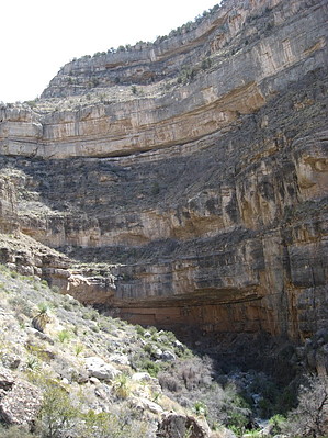
If you are not hiking the full trail, Instead of stopping at the cabin ruins, add a bit more to your day and ascend the trail to the exceptional overview just a bit further up the trail. There is a great dry rock waterfall area that provides some protection from the wind and a natural sitting area. The little bit of extra climbing is worth the effort; the views are exceptional!
Enjoy!
There is a day use fee for parking down in the New Mexico State Park. Check out the interesting displays, including a picture of the old line shack before it fell into ruins. The camp grounds provide electricity and hot showers!
Lincoln FS Details The National Recreation Dog Canyon Trail is 5.5 miles long. It begins at Oliver Lee State Park and ends at Forest Road 90B. This beautiful trail traverses up from the desert to elevations over 2000' above its starting point and is a trail for the experienced hiker. The trail is open for the following uses: Hiking, Horseback Riding.
When hiking several trails on a single "hike", log it with a generic name that describes the hike. Then link the trails traveled, check out the example.
WARNING! Hiking and outdoor related sports can be dangerous. Be responsible and prepare for the trip. Study the area you are entering and plan accordingly. Dress for the current and unexpected weather changes. Take plenty of water. Never go alone. Make an itinerary with your plan(s), route(s), destination(s) and expected return time. Give your itinerary to trusted family and/or friends.
Permit $$
information is in description
Directions
Road
Paved - Car Okay
To hike From Alamogordo, take state road 54 8.8 miles to the signed turnoff for Oliver Lee State Park. Turn left... follow the road to it's end, four miles... pay the self service fee to park inside the park or park outside the gate on the BLM land. The trail begins immediately behind the Visitor Center.
 Route Editor


