Route Editor

| Guide | ♦ | 11 Triplogs | 0 Topics |
details | drive | no permit | forecast | route |
stats |
photos | triplogs | topics | location |
| 181 | 11 | 0 |
The other route by sneakySASQUATCH Particularly during monsoon season it is highly recommended to be down to the treeline before noon to avoid lightning strikes from afternoon thunderstorms. There have been fatalities on Pikes Peak and it is a hotbed in comparison to other areas of Colorado for lightning strikes.
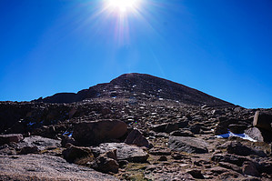
The trail head starts just beyond the Rocky Mountain Mennonite Camp. Crossing the stream and following it through the forest. The only navigation necessary during this hike other than following cairns a the boulder field at the top is following the sign for Devil's Playground and crossing Fourmile Creek on to #664a. This is a little confusing because you are hiking Pikes Peak via the Crags and the sign if you go straight is for the hike up to the Crags which is a rock formation visible along the trail. After crossing the creek the trail becomes rocky and continues through the forest with switchbacks until getting above the treeline. As you climb you will be able to see rock formations to your left and on a clear day get amazing views of the continental divide to the west. After getting above the treeline it is a steep climb up to the Saddle at about 12,700'. At this point there are cairns so large they appear to be grave markers. Probably to be visible in the winter with a snow pack. You can see the trail which goes to the crossing of the highway into the Devil's Playground named according to the sign, for the way the lightning dances from rock to rock during Thunderstorms, which I'm not sure I want to see! The trail follows the highway for a bit which is a bummer, but the views to left (east) of the drop and the reservoirs is amazing! The final assault or last 1000' feet is a boulder field and following cairns. It's kind of like Flatiron at 13000' w/out any vegetation. It was icy in spots with a lot of lose rocks so be forewarned. I can't imagine doing this section with a base of snow. It is easier navigating down than up. As you approach the top there is an army building, but on a clear day the public restaurant, gift shop, Cog railway building is visible. Have fun! Check out the Official Route and Triplogs. Note This is a moderately difficult hike. Leave No Trace and +Add a Triplog after your hike to support this local community. | |||||||||||||||||||||||||||||||||||||||||||||||||||||||||||||||||||||||||||||||||||||||||||||