 Route Editor

| Guide | ♦ | 2 Triplogs | 1 Topic |
details | drive | permit | forecast | map |
stats |
photos | triplogs | topic | location |
| 7 | 2 | 1 |
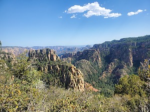
Secret canyon's rim secret by ShatteredArm  Overview OverviewThe Sedona area has many canyons, but Secret Canyon is one of the more extensive, scenic, and secluded. Along Secret Canyon's north rim, many maps show a trail starting near the end of FR539, heading south over Little Round Mountain and then following the rim west for about a mile and a half. The Forest Service map simply shows this trail as "9". I could not find a reference to this trail on the Coconino National Forest website. Given the above, (a) it is not really clear if this trail has an official name, and (b) hikers should not expect anything resembling a maintained trail or, for most of the hike, any trail at all. Hikers can, however, expect some truly spectacular views of Secret Canyon, Maroon Mountain, and the Dry Creek drainage.
The route begins at an excellent campsite (with an outstanding view of Dry Creek, Wilson Mountain, and Capitol Butte) a short distance from the end of FR539, right above a saddle connecting to Little Round Mountain. There is no signage, but there are signs of traffic along the narrow saddle. FR539C down to South Pocket Tank comes within feet of this saddle; avoid the urge to follow the road. Cairns appear when starting the short ascent up Little Round Mountain, and mark a route all the way to the Secret Canyon rim. There is no trail along this route, but one can almost always see from one cairn to the next. Near the mountain's high point, the cairned route diverges from the line on the maps, taking a more westerly route, but still winding up in the same area. Once you reach the vicinity of the rim, you can either continue southeast to a significant promontory or head west along the ridge that forms between Secret Canyon and South Pocket. The first short descent off of Little Round Mountain appears brushy at first, but there is a relatively clear path the whole way down to the next saddle if you generally stay to the right of the manzanita and scrub oak (the brush is really just there to help you avoid falling into the canyon). This first saddle is broad and grassy, and the rim here features an excellent view into the canyon, wherein you can clearly see secret Canyon Arch. As you proceed west, the ridge becomes more pronounced, and South Pocket further down below you on the right. There are a few short stretches of what seems like the actual trail along this stretch, but it's generally "choose your own adventure", with the South Pocket (north) side offering easier travel. The line on the map ends at a rock outcropping with a more significant drop to the next saddle (although it would not be difficult to get to this saddle and continue along the ridge). Here, there is a dramatic view of Secret Canyon, Maroon Mountain, and its little ridge connecting it to Secret Mountain. It also offers a decent view of the maze of tributary canyons to Secret Canyon, although it is partially obstructed by the ridge you are standing on. Camping There are two or three world-class campsites in the vicinity of the trailhead, although you may need to get there early to claim one of them.
Check out the Triplogs. Leave No Trace and +Add a Triplog after your hike to support this local community. One-Way Notice This hike is listed as One-Way. When hiking several trails on a single "hike", log it with a generic name that describes the hike. Then link the trails traveled, check out the example. | |||||||||||||||||||||||||||||||||||||||||||||||||||||||||||||||||||||||||||||||||||||||||||||||||


