 Route Editor

| Guide | ♦ | 4 Triplogs | 0 Topics |
details | drive | no permit | forecast | route |
stats |
photos | triplogs | topics | location |
| 0 | 4 | 0 |
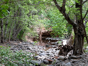
Weir's the Beef! by HAZ_Hikebot   The Wier Trail provides easy access to Wet Beaver Creek as it contours from near the information board on the Bell Trail before dropping to creek level at the gaging station. The gaging station is used by the USGS to record stream-flow information. Please stay away from the gaging station and do not tamper with the equipment. The Wier Trail provides easy access to Wet Beaver Creek as it contours from near the information board on the Bell Trail before dropping to creek level at the gaging station. The gaging station is used by the USGS to record stream-flow information. Please stay away from the gaging station and do not tamper with the equipment.The vegetation found near the junction of the Bell and Wier Trails is typical Upper Sonoran species: prickly pear, agave, catclaw, and juniper. Once the trail reaches the creek the vegetation changes dramatically. The Upper Sonoran species are replaced by riparian vegetation consisting of Arizona black walnut, willow, ash, sycamore, cottonwood, canyon grape, blackberries, and poison ivy (learn to identify and avoid this three-leaved plant).
Check out the Official Route and Triplogs. Leave No Trace and +Add a Triplog after your hike to support this local community. One-Way Notice This hike is listed as One-Way. When hiking several trails on a single "hike", log it with a generic name that describes the hike. Then link the trails traveled, check out the example. | |||||||||||||||||||||||||||||||||||||||||||||||||||||||||||||||||||||||||||||


