Route Editor

| Guide | ♦ | 5 Triplogs | 0 Topics |
details | drive | no permit | forecast | route |
stats |
photos | triplogs | topics | location |
| 77 | 5 | 0 |
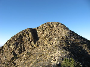
Mild Organ Mountain Summit by Jim  The main summits in the Organ Mountains are more climbing or technical hiking, but Baylor Peak offers a class 2 to extremely easy class 3 hike, with a well built trail for almost 6 of the 7.5 total hiking miles. After the well built trail, a pretty good social trail takes you to the summit. Because you are north of the main group of peaks, you will not have views to the south, except of those peaks, unless the sun blocks the view. You still have the other 270 degrees of views off the mountain.
Once making the easy to reach pass, find the well worn social trail leading north and up slope to Baylor Peak. It is very easy to find for 95% of the hike, but a little difficult to find for a few small sections while going up. Down it is nearly impossible to miss. The trail is not official or well built, and at times it seems to have been worn down by some sadomasochists, as it takes you by, through, and between a lot of dagger, cholla, and other pointy plants and through the dominant "tree" of the range: the brushy and somewhat dead Mountain Mahogany. You'll traverse over gravel slopes and some loose rock that can be slippery with gravel. Be careful on this off trail, or social trail hike, but it is very doable. Return the way you came and use caution, as falling could plant you in a cactus or some other angry plant. Once back on the trail, it is smooth sailing to the parking lot. I ran for at least a mile of the best gravel sections of trail. The summit of Baylor Peak is mapped at 7,721', but it hardly feels it. I attribute this to the desert nature of the range. Cactus and brush all the way to the top, with hardly any juniper to be found. Dry is an understatement here. From studying the Organ Mountains from the area around them and in satellite images, there is hardly any tree growth outside of drainages and protected north slopes. This range is something of a wall in the desert, so it probably gets very little rain in a good year. It is also a windy range, as I experienced when I first came to summit this. Baylor is at the north end of the quartz monzonite rock section of the range, so it has some of the steep rugged appearance of the other noteworthy peaks in the range. According to what I have read, the most attractive and famous part of the range is composed of this quartz monzonite, south of the steeped peaks is an area of rounded extrusive rhyolite, and south of that the range turns to limestone, which seems to comprise the bulk of the areas mountains, from the military base closed San Andreas Range to the north, to the Sacramentos and Guadalupes to the east, and the Franklins to the south. On a clear day, views should extend from the Florida Mountains to the west, the Black Range in the Gila to the northwest, the long thin San Andreas (representing a very easy to see west tilting fault-block range) to the north, the Sierra Blanca and Sacramentos to the east and possibly the high point of the Texas to the southeast. Enjoy. Check out the Official Route and Triplogs. Leave No Trace and +Add a Triplog after your hike to support this local community. | |||||||||||||||||||||||||||||||||||||||||||||||||||||||||||||||||||||||||||||||||||||