username
X
password
register
for free!
help
 
   🔥

St Clair Peak 4230 - Tonto NF, AZ

Guide 12 Triplogs  0 Topics
  2.6 of 5  
Fav
Wish
2
details
drive
permit
forecast
🔥
route  
stats
photos
triplogs
topics
location
130 12 0
HAZ reminds you to respect the ruins. Please read the Archaeological Resources Protection Act of 1979 & Ruins Etiquette
Statistics
tap row or icons for details
Difficulty 2 of 5
Route Finding 2 of 5
Distance Round Trip 4.23 miles
Trailhead Elevation 3,684 feet
Elevation Gain 500 feet
Accumulated Gain 827 feet
Avg Time Round Trip 3 hours
Kokopelli Seeds 8.37
 Interest Off-Trail Hiking, Ruins, Historic & Peak
 Backpack No
unreported if dogs are allowed
editedit > ops > dogs to adjust
feature photo
Photos Viewed All MineFollowing
Inaugural Calculation on Button Tap!
12  2024-02-05 LindaAnn
2  2023-10-13 FOTG
24  2023-05-09 NitroTheWolf
24  2023-01-07
St. Clair Peak and Indian Butte
John10s
13  2022-02-17 Oregon_Hiker
9  2022-01-18 BobP
7  2017-01-29 Alston_Neal
14  2014-01-12 Hippy
Page 1,  2
Author
author avatar Guides 9
Routes 74
Photos 297
Trips 22 map ( 116 miles )
Age 21 Male Gender
Location Scottsdale / Flagstaff
Associated Areas
list map done
Phoenix Region
Historical Weather
Trailhead Forecast
Radar Map
Expand Map
Preferred Oct, Nov, Dec, Jan → 7 AM
Seasons   Autumn to Spring
Sun  6:03am - 6:49pm
Official Route & 5 Rts
 
2 Alternative
 
Historic Fire Perimetersacres
🔥 Bart 200530.8 mi*
🔥 2020 Sears Fire14.5k
🔥 2019 Mountain Fire493
🔥 2005 St. Clair7.4 mi*
🔥 2005 Cave Creek Complex169.4 mi*
🔥 2005 Bart Fire16.2k
🔥 2005 Bart27.1 mi*
🔥 1991 St. Clair Fire7.9 mi*
🔥 1979 Verde Fire22.9k
🔥 1974 Indian Fire7.8 mi*
🔥 View (All) - over Official Route 🔥
*perimeter length in miles


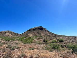
Saint Clair Summit Hike
by NitroTheWolf

 
Overview
Saint Clair Summit Hike is a ~4.23-mile hike up to the summit of Saint Clair Mountain. There is ~826 elevation gain and the hike follows a jeep trail then you have to bushwack to the top.
33.897567, -111.750167
Hike
You can park at the Kentuck Mountain staging area but do not block the gate.
Enter the trail at this gate. N 33 53.854 W 111 45.010


When you reach the trailhead, you will have to jump over a locked gate, as the first part of the trail used to be a jeep trail but is now locked off to vehicles. You will follow this jeep trail for ~1.3 miles. At the 0.2-mile mark, you will pass a gated area that contains a waterhole. You are not allowed to camp within 1/4 mile of this waterhole.
remove free decal offer
When you reach the ~1.3 mile mark the jeep trail splits. You will see a trail that is even more overgrown which heads straight, while the jeep trail turns right. Follow the overgrown trail straight ahead. The overgrown trail proceeds to curve around the mountain towards the saddle over ~0.5 miles. This trail will become more overgrown until it eventually stops near the saddle at around the ~1.8-mile mark. You will need to bushwack the remaining ~0.4 miles to the top.

This is where the trail becomes a bit hard. The last ~0.4 miles gain ~500 feet as you climb to the top. There is a wash area where you can try to walk up, it's definitely easier than bushwacking through the tall grass. Near the summit, there are some Native American ruins, please treat the area with respect and take only pictures and leave only footprints.

The summit is now very close, there were lots of gnats on my hike. There is also a summit register at the top located at these coordinates (N 33° 53.869' W 111° 43.717') When going down, make sure the rocks you are stepping on are stable so you don't tumble down the mountain.

Gate Policy: If a gate is closed upon arrival, leave it closed after you go through. If it is open, leave it open. Leaving a closed gate open may put cattle in danger. Closing an open gate may cut them off from water. Please be respectful, leave gates as found. The exception is signage on the gate directing you otherwise.

2023-09-04 NitroTheWolf


    Check out the Official Route and Triplogs.
    Leave No Trace and +Add a Triplog after your hike to support this local community.
    WARNING! Hiking and outdoor related sports can be dangerous. Be responsible and prepare for the trip. Study the area you are entering and plan accordingly. Dress for the current and unexpected weather changes. Take plenty of water. Never go alone. Make an itinerary with your plan(s), route(s), destination(s) and expected return time. Give your itinerary to trusted family and/or friends.

     Permit $$
    Tonto Pass is required.


     Directions
    or
     Road
    FR / Dirt Road / Gravel - Car Okay

    To hike
    From the 101 Loop & N Scottsdale Rd
    1) Take N Scottsdale Rd: 4.8 mi
    2) Turn right onto E Jomax Rd: 2.0 mi
    3) Turn left onto N Pima Rd: 6.3 mi
    4) Turn right onto E Cave Creek Rd: 4.2 mi
    5) Turn right onto Bartlett Dam Rd/Srv Rd 205: 6.3 mi

    Turn left onto N Horseshoe Dam Rd/Srv Rd 205
    The destination is on the left
    page created by mazatzal on Sep 04 2023 8:00 pm
     90+° 8am - 6pm kills
    helpcorrectionissue

    end of page marker