Route Editor

| Guide | ♦ | 3 Triplogs | 1 Topic |
details | drive | no permit | forecast | 🔥 route |
stats |
photos | triplogs | topic | location |
| 48 | 3 | 1 |
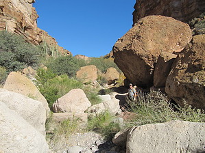
Ok for us 60+ hikers by bensondk   Overview OverviewThis hike is the completion of an effort to connect White Canyon from two different directions, the northeast, and the south. Initially, I hiked into White Canyon from the northeast (Official trail in HAZ by Grasshopper as White Canyon Upper - SW Approach FR319). As Grasshopper describes, the northeast approach takes you to the top of the valley with some fantastic views of White Canyon. Further investigation showed several approaches from the south from Battle Axe Road, but no routes connected to the top of the ridge where the northeast approach ended. The track described below results from a combined effort with George from Solera, who recorded the initial track. The accompanying GPS Route helps pick the right general area, but it may not follow the best line in places. It does become very helpful in knowing where to leave the creek to go up to the top of the valley to the right.
Hike from South The first 1.1 miles of the hike is on a traveled road, mainly used by off-road vehicles. It passes a fixed-up spring with a pipe coming out of the ground keeping a pool filled. Later I was told that this spring is warm water, although I didn't think to feel it at the time. As you hike in on the road, the cliffs to the side become more rugged and impressive. Where the creek bed separates into two, the road follows one, and the track takes the other as you work your way up the creek. About 0.2 miles from the road, you are likely to encounter a registration stand. This registration stand is located in a remote location and contains a surprising number of entries. It seems likely that some hikers going up the creek bed would miss the registration completely. As you work your way up the creek, you will encounter all sizes of boulders, some of which will test your scrambling skills, but none of which required any special skills other than picking the easiest route. A trail can be found for much of the way, but it will disappear from time to time, particularly where the trail is right at the bottom of the creek. After about 3 miles from the parking spot, you will come to a waterfall (likely dry) on your right. This is where you leave the creek bed and turn uphill. At first, this will appear to be impossible to scramble, but if you look closely at the left-hand side, you can begin to see a path, and as you work your way up, you find that it is indeed not that difficult to scramble. If you use a series of switchbacks, the otherwise very steep track can be made much easier. Initially, we thought that it might be ok going up, but it could be challenging to descend later, but descending turned out to be relatively easy as well. Compared to the hike up to Picket Post summit, those familiar with that hike will find this route by the waterfall slightly easier and much shorter in duration. Once at the top, we returned the same way we came. For hikers in this area for the first time, I would encourage you to go further to the north along the edge of the valley to take as many scenic lookout points as time allows. If transportation can be worked out to combine this track with the one called White Canyon Upper - SW Approach FR319, an excellent outing can be had by hiking from one trailhead to the other. Check out the Official Route and Triplogs. Note This is a moderately difficult hike. Leave No Trace and +Add a Triplog after your hike to support this local community. | ||||||||||||||||||||||||||||||||||||||||||||||||||||||||||||||||||||||||||||||||||||||||||||||||||