Route Editor

| Guide | ♦ | 2 Triplogs | 0 Topics |
details | drive | permit | forecast | route |
stats |
photos | triplogs | topics | location |
| 65 | 2 | 0 |
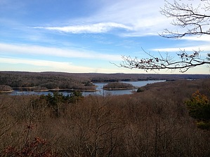
The devil is in the details! by chumley History Archaeological evidence shows human activity in the preserve as far back as 5000 years. In more modern history, European settlers used the waters of the surrounding lands for hunting, charcoal production, and milling. In 1966, 1,100 acres of land was initially purchased from the Bridgeport Hydraulic Company by the late Katharine Ordway for preservation. The additional acreage was purchased over the next two years. The name is derived from an ancient legend, where a hoof-like mark in one of the preserve's rock ledges was said to be the devil's footprint.
Flora and Fauna The preserve features a contiguous area of woodlands that are an ideal home to numerous species of flora and fauna. As many as 500 types of trees, bushes, plants, and flowers provide habitat for dozens of species of mammal, including deer, fox, bobcat, and coyote. There are over 140 bird species, the largest of which include duck, pheasant, and turkey. Geology The preserve consists mainly of a series of ridges and valleys generally running north-south. The ridges generally rise 30-100 feet above the adjacent valley. The ridges are often rocky ledges and some offer views beyond the trees to distant hills. In autumn, a few points feature excellent views of New England's foliage. The valleys that run parallel to the ridges typically feature marshy wetlands or small brooks and streams. Some of the streams offer scenic flows and small cascades. The overall elevation of the park rises from south to north, with the parking area at an elevation of about 300 feet, and the highest points in the north part of the preserve at nearly 600 feet. Hiking There are over 20 miles of marked trails in the preserve. Yellow blazes mark hiking trails, while red blazes mark trails suitable for cross-country skiing. White blazes mark some trails, including those that connect to non-Devil's Den preserve trails. It seems that there are many more named trails than necessary, possibly as a result of honoring donors with a named trail. Many of the trails are old double-track wagon trails, while some are more wooded single-tracks. All are well-marked and easy to follow. Crossing streams and wetlands are generally made easy with raised walkways and bridges, but in times of unusual moisture or after rain, waterproof footwear is recommended. Loops can be made in varying distances for almost any hiking skill level, from 1/2 mile strolls with small children up to about 10 miles. Longer hikes can be made by covering some terrain more than once to reach unhiked trails. There is no right or wrong way to visit the preserve, and the numerous trails provide numerous options for variety. Highlights include the stream and waterfalls in Ambler Gorge, as well as the Ambler Vista above it. The vistas to the east looking over Saugatuck Reservoir and the hills of Monroe and Newtown seen from the extreme northeast corner of the preserve along the Great Ledge Trail are also a worthy sight. And the rocky hike along the ridgeline of the Hiltebeitel Trail is another unique trail worth seeing. Of course, Godfrey Pond is a must-see, and is one of the more frequently visited spots in the preserve, and is only a 10-15 minute walk from the parking lot. For the history buffs, there's old portable mill equipment near the end of the Den Trail, just south of the Donahue trail junction. Suggested Loops: ~8.5 miles: Laurel-Troop 7-Aspetuck-Godfrey-Dayton-Ledge-Deer Run-Bruzelius-Cedar Cliff-Bedford-Moller-Donahue-Saugatuck-McDougal West-Pent ~5.5 miles: Laurel-Godfrey-Bedford-Den-Pent ~4 miles: Laurel-Godfrey-Sap Brook-Saugatuck-McDougal West-Pent ~2.5 miles: Pent-Sap Brook-Hiltebeitel-Deer Knoll-Harrison-Pent ~1.5 miles: Pent-Harrison-Godfrey Pond-Laurel Maps Detailed maps and information can be found at The Nature Conservancy website for Devil's Den Additionally, downloadable GPS tracks including distance and elevation profiles for each of the individual trails in the preserve are available here on HAZ.
Check out the Official Route and Triplogs. Leave No Trace and +Add a Triplog after your hike to support this local community. | |||||||||||||||||||||||||||||||||||||||||||||||||||||||||||||||||||||||||||||||||||||