Route Editor

| Guide | ♦ | 3 Triplogs | 0 Topics |
details | drive | no permit | forecast | 🔥 route |
stats |
photos | triplogs | topics | location |
| 50 | 3 | 0 |
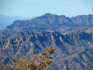
hemoglobin > oxygen > 5822 > blood by pseudalpine   Overview OverviewAn interior chaparral hill located in the Superstition Wilderness on the north side of FR 650 about halfway between the Rogers Trough TH and Montana Mountain 5557. Hike The first quarter mile follows an old road that becomes indiscernible when it crosses a wash tangled with wait-a-minute bushes. There is no 'trail' from this point, so it's a matter of picking your way through very few open areas amongst the fairly recently burned landscape. About midway, the regrown vegetation becomes thicker with interspersed doses of manzanita, but several game trails create a manageable track, so it isn't a horrible bushwhack. Once attaining the ridgeline, a fenceline can be followed left to the rocky summit.
An elevated view mainly west across to Iron Mountain. The southern view is of more chaparral, the southwest is the same view as from FR 172A, and the Pinto Valley Mine scar dominates to the northeast. Check out the Official Route and Triplogs. Leave No Trace and +Add a Triplog after your hike to support this local community. | ||||||||||||||||||||||||||||||||||||||||||||||||||||||||||||||||||||||||||||||||||||||||||||||||