username
X
password
register
for free!
help
 

Peak 3125 - Goldfields, AZ

Guide 33 Triplogs  0 Topics
  3.4 of 5 
Fav
Wish
1
details
drive
no permit
forecast
route  
stats
photos
triplogs
topics
location
191 33 0
Statistics
tap icons for details
Difficulty 2.5 of 5
Distance One Way 1.8 miles
Trailhead Elevation 1,922 feet
Elevation Gain 1,247 feet
Accumulated Gain 1,251 feet
Kokopelli Seeds 5.97
 Interest Off-Trail Hiking & Peak
unreported if dogs are allowed
editedit > ops > dogs to adjust
feature photo
Photos Viewed All MineFollowing
Will recalculate on button tap!
24  2022-03-26
Ironwood Ridgeline and Four Goldfield Peaks
John10s
30  2021-12-23 adilling
12  2021-02-07
Four Goldfield Peaks
DixieFlyer
3  2020-11-17
Peak 3004 Loop - Goldfield Mtns
Daytripper
35  2020-10-18 adilling
10  2019-09-21
Hippy Hill 3163
chumley
16  2019-04-12
Peak 3108 Ridgeline Plus
DixieFlyer
4  2019-03-02 jamminaz
Page 1,  2,  3
Author
author avatar Guides 16,883
Routes 17,294
Photos 24
Trips 1 map ( 6 miles )
Age 26 Male Gender
Location HAZ, TrailDEX
Associated Areas
list map done
Phoenix Region
Historical Weather
Trailhead Forecast
Radar Map
Expand Map
Preferred Jan, Feb, Mar, Dec
Sun  5:20am - 7:27pm
Official Route
 
6 Alternative
 
 Water


Guide Needed
Publish Full Detail Guide


Use +Add above to share photos and triplogs
Overview: Meridian TH to the Peak of 3125'.
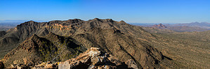
Check out the Official Route and Triplogs.


Leave No Trace and +Add a Triplog after your hike to support this local community.

2012-12-28

    One-Way Notice
    This hike is listed as One-Way.

    When hiking several trails on a single "hike", log it with a generic name that describes the hike. Then link the trails traveled, check out the example.
    WARNING! Hiking and outdoor related sports can be dangerous. Be responsible and prepare for the trip. Study the area you are entering and plan accordingly. Dress for the current and unexpected weather changes. Take plenty of water. Never go alone. Make an itinerary with your plan(s), route(s), destination(s) and expected return time. Give your itinerary to trusted family and/or friends.

     Permit $$
    no fees or permits reported

    if incorrect tell us about it


     Directions
    or
    or
     Road
    Paved - Car Okay

    To Meridian Trailhead
    Meridian Trailhead is located at the north terminus of Meridian Road between Mesa and Apache Junction.

    US60 to Signal Butte. Take Signal Butte north to University. East (right) onto University to Meridian. North (left) onto Meridian to the terminus. There is a small TH.

    or

    Exit 202 Loop at Brown Road and travel east on Brown Road for about 3.5 miles. From Brown Road (Lost Dutchman Rd), travel North on Meridian for two miles to the trailhead parking area at the end of the road.

    From PHX (I-10 & AZ-51) 34.1mi - 44 mins
    From TUC (Jct 1-10 & Grant) 119mi - 2hr 11mins
    From FLG (Jct I-17 & I-40) 176mi - 2hr 56mins
    page created by TheNaviG8R on Dec 28 2012 12:22 pm
     90+° 8am - 6pm kills
    Avoid Heat Illness - stay cool
    helpcorrectionissue

    end of page marker