Route Editor

| Guide | ♦ | 11 Triplogs | 1 Topic |
details | drive | permit | forecast | route |
stats |
photos | triplogs | topic | location |
| 129 | 11 | 1 |
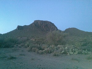
Hike up the double humped camel by NitroTheWolf  Overview OverviewDromedary Peak is a mountain located on State Trust Land near the US 60. It is located south of the Superstition Mountains. There are two peaks, the smaller one has an elevation of ~2,800 while the larger one has an elevation of 3,016. A State Land Trust permit is required to park and hike on these lands. At the top, you will be greeted with amazing views of Weaver's Needle and the Superstition Mountains.
GPX track I created when hiking up. History In 1938 a Triangulation Station Disk with a PID of DU2076 and a designation of DROMEDARY was placed on top of the mountain. This is the only information I currently have on this peak. Hike Entrance to the State Trust Lands is at N 33 15.8403' W 111 15.3853'. The road to the parking waypoint is dirt, but most vehicles should be able to make it, 4wd is not required. There is a gate you will have to open once you pull off, make sure to close it again once you have made it through. Drive through the wash, if it is dry, then go right when the road forks, and park at N 33 15.5857' W 111 15.0991'. Go down into the wash, then start your climb to the summit. At this point, try your best to hike up the game trails to the summit, or follow one of the GPX tracks in the triplogs. The hike up is quite steep. Near the summit there are a bunch of loose rocks, so watch your footing. As you reach the summit, it starts to flatten out. Lots of big boulders up here. There is also a geocache/summit log located at the summit, so make sure to sign it. As you descend the peak remember to be careful where you put your feet/hands and there is a possibility of loose rocks and/or wildlife. Water Sources There is a wash that runs parallel to Jeep trail, but unless it has flooded recently don't plan on there being any water. Camping As this is State Trust Land you can camp here for a maximum of 14 days and while there are no designated camping sites, there are many pull-offs and campfire pits that are located nearby. Gate Policy: If a gate is closed upon arrival, leave it closed after you go through. If it is open, leave it open. Leaving a closed gate open may put cattle in danger. Closing an open gate may cut them off from water. Please be respectful, leave gates as found. The exception is signage on the gate directing you otherwise. Check out the Official Route and Triplogs. Leave No Trace and +Add a Triplog after your hike to support this local community. | ||||||||||||||||||||||||||||||||||||||||||||||||||||||||||||||||||||||||||||||||||||||||