Route Editor

| Guide | ♦ | 17 Triplogs | 0 Topics |
details | drive | no permit | forecast | route |
stats |
photo | triplogs | topics | location |
| 1 | 17 | 0 |
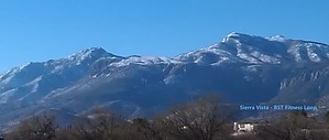
Mountain Views in Sierra Vista by MAVM  One of the benefits of Sierra Vista's moderate climate is that hiking is an all-season activity. The Sierra Vista BST Fitness Loop uses a paved loop trail - < 10 km / 6 miles entirely on a multi-use path. Great views of the Huachuca and Mule Mountains. The route is lightly used most days, making cycling at speed relatively easy. If your preference is fitness walking, Sierra Vista currently has 20 miles of multi-use paths throughout the City. One of the benefits of Sierra Vista's moderate climate is that hiking is an all-season activity. The Sierra Vista BST Fitness Loop uses a paved loop trail - < 10 km / 6 miles entirely on a multi-use path. Great views of the Huachuca and Mule Mountains. The route is lightly used most days, making cycling at speed relatively easy. If your preference is fitness walking, Sierra Vista currently has 20 miles of multi-use paths throughout the City.There are trails available for every person's physical ability and motivation, from the level riverbank trails along the San Pedro River to the Coronado National Forest's alpine trails. The Friends of the San Pedro River (FSPR) have regularly scheduled hikes, walks, and historic tours in the San Pedro Riparian National Conservation Area.
Located at the center of one of the finest birding areas in the United States, Sierra Vista is often referred to as "The Hummingbird Capital of the U.S." The mild climate, proximity to Mexico, and diverse habitats, including 9,000-foot mountains and the magnificent San Pedro River Valley, make southeastern Arizona a major hot spot for rare and unusual species of birds. Check out the Official Route and Triplogs. Leave No Trace and +Add a Triplog after your run to support this local community. | |||||||||||||||||||||||||||||||||||||||||||||||||||||||||||||||||||||||||||||||||||||