Route Editor

| Guide | ♦ | 6 Triplogs | 0 Topics |
details | drive | no permit | forecast | 🔥 route |
stats |
photos | triplogs | topics | location |
| 17 | 6 | 0 |
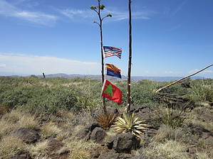
Scratchy hike with a view by BEEBEE   Overview OverviewBlackjack point is the highest prominence on Cooks Mesa. The peak itself is not a very difficult off-trail hike. It is located on the southeast end of Cooks Mesa. The summit provides 360-degree views of the Mesa, Mazatzal Mountains, Seven Springs, Humboldt Mountain, and the valley below. Warning The road leading to the summit is strictly high clearance 4wd when dry and likely much more challenging when wet or downright dangerous during a monsoon storm. Park at FR 24 and FR 597 and hike up FR 597 to the mesa before climbing the hill.
The hike itself is unremarkable. I would recommend parking near the intersection of FR 24 and FR 597, proceeding up FR 597 to the mesa. Along the way, you will come to a closed gate and then two other open gates. After the second open gate, you will find yourself on the mesa. Go south on FR 600. You will see a fence running up to the ridge. I recommend staying on the road till after the fence and then picking your way up the hill to the point. The hill itself has lots of low brush, and pants are recommended. However, there are plenty of rocks you can hop on to stay out of it all. As you work your way along the ridge and take in the view, you will see a fence. Once you cross that fence, you are about 150 feet from the official summit area. Once you arrive at the summit, enjoy the view and relax. Gate Policy: If a gate is closed upon arrival, leave it closed after you go through. If it is open, leave it open. Leaving a closed gate open may put cattle in danger. Closing an open gate may cut them off from water. Please be respectful, leave gates as found. The exception is signage on the gate directing you otherwise. Check out the Official Route and Triplogs. Leave No Trace and +Add a Triplog after your hike to support this local community. | ||||||||||||||||||||||||||||||||||||||||||||||||||||||||||||||||||||||||||||||||||||||||||||||||||