Route Editor

| Guide | ♦ | 21 Triplogs | 0 Topics |
details | drive | permit | forecast | route |
stats |
photos | triplogs | topics | location |
| 143 | 21 | 0 |
Keep this under wraps! by chumley  History HistoryThis cluster of hills in Paradise Valley is part of the "range" known as the Phoenix Mountains. In the 1930s, Swiss-born Charles Mieg, a successful New York City banker and real estate mogul, moved to Arizona and prospected for gold in the Bradshaw Mountains. By the early 1940s, he had moved to the area that would later become PV and was captivated by the mountain then known as Windy Gulch. Mieg purchased the Van Benscoten Ranch for $12,000, which included most of the land on the north and east sides of Windy Gulch. When viewing the mountain's profile from the dirt road later to be named Shea Blvd, he thought that it resembled an Egyptian mummy laying down, so he began using the name Mummy Mountain when he marketed his newly purchased land for development. Mummy Mountain Preserve Trust That development slowly encroached on the mountain itself, until in 1997 the Mummy Mountain Preserve Trust was established to preserve the natural landscape of the mountain, primarily along the peaks and ridgelines in a parcel of land that totals about 320 acres. Over the years, much of the land encompassing the preserve has been donated or purchased by the Trust, and as of 2012, more than 200 acres are held by the trust. This map shows the borders (close, but not exact) of the Preserve as of 2012. The yellow line shows the PRESERVE, while the green line shows land that is PUBLIC (donated or purchased by the Trust). That means that the land inside the yellow border, but not inside a green border is PRIVATE land!
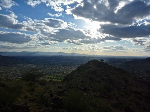
Warning Ascending to the summit of Mummy Mountain is no easy task. There is no trail, and the grade is very steep. The footing is loose and scree-covered. This should not be attempted by anybody who is not comfortable with moderate scrambling, (requiring the use of hands to climb, with some exposure). THERE IS NO TRAIL!! The Hike/Climb Start at the northern end of the J. W. Marriott Camelback Inn Resort and Spa. If you are not a guest of the resort, you may want to ask permission from the front desk to park your vehicle on resort property, or to hike on the lower portion of this trail which lies entirely on private resort property. The resort may tow vehicles not registered to guests. Begin the hike by walking through the fake western town titled "Mummy Mountain". At the far end, there is a bridge that crosses a small wash and a sign that introduces you to "Tyner's Hiking Trail" - a pair of hiking trails on resort property. Take the blue trail in either direction of the loop and follow it to the wooden bench at the high-point of the loop. From here, leave the resort trail and proceed uphill on the noticeable use-trail which heads up a gully. Eventually, you will want to veer to the left and climb the ridge toward the top. There are some use paths to follow, but you are largely on your own from here. The first peak you reach is a bit lower than the actual summit of Mummy Mountain, so you will have to proceed northeast to the peak, which is marked by some utility structures and a large solar panel. Enjoy the 360-degree views of Paradise Valley, Camelback Mountain, downtown Phoenix, Piestewa Peak, and the rest of the Phoenix Mountains, the north valley, Pinnacle Peak, and the McDowells, Four Peaks, Red Mountain, and the Superstitions! Head back down the way you came! Check out the Official Route and Triplogs. Note This is a moderately difficult hike. Leave No Trace and +Add a Triplog after your hike to support this local community. | |||||||||||||||||||||||||||||||||||||||||||||||||||||||||||||||||||||||||||||||||||||||||||||||||||||||||||||||||||||||||||||||||||||||||||||||||||||||||||||||||||||||||||||||||||||||||||