Route Editor

| Guide | ♦ | 9 Triplogs | 0 Topics |
details | drive | permit | forecast | 🔥 route |
stats |
photos | triplogs | topics | location |
| 116 | 9 | 0 |
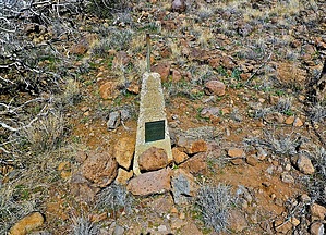
Journey to the Frustum by NitroTheWolf  Warning WarningBefore you head out here, make sure you have enough water and a capable vehicle. There is little to no cell service out here. The road out here is dirt, and while any car should be able to make it, it helps to have high clearance. Overview This is a short and steep hike that will take you to the top of Monument Mountain, where there is a survey marker, and to the Yavapai and Maricopa County border where there is a frustum marking the boundary of the counties.
To get here, follow N Cave Creek Road until it turns into N Seven Springs Road/Forest Road 27. You will come to a bend after about 15 miles of road. Do a sharp U-turn onto FR 41 (N 34° 00.549 W 111° 52.788 ) and follow for it 1.5ish miles till you get to N 34° 00.513 W 111° 53.744, there is a pull-off here. History Monument Mountain is a mountain located in the Tonto National Forest near the intersection of FR 24 and FR 41. There is a triangulation station survey marker located on the summit of Monument Mountain. The designation is COOK, the PID is ES1001, it's a bronze disc, and it is set in a rock outcrop. It was monumented in 1924 by COAST AND GEODETIC SURVEY with an elevation of 5002 feet above sea level. At the Yavapai and Maricopa county line, there is a two-foot-high concrete frustum. It is Boundary Monument #25 for Maricopa and Yavapai Counties. The frustum has a pipe driven through the top of it into the ground to keep it stable. Rocks are piled up at the base of the frustum. There are three brass plates embedded in the frustum and display MARICOPA COUNTY 1924 on one, YAVAPAI COUNTY 1924 on another, with the third side stating the course and distance to the next numbered frustum to the west and the east. Hike The two best GPX routes up are my track and Flying Fliver's track. Flying Fliver's track is a bit longer and steeper than mine. Use Flying Fliver's triplog for reference if you are using his track. The hike up starts easy, but after 0.1 miles it will become very steep. There are a lot of loose rocks and soil. Going straight up is by far the shortest distance to the top, but depending on your skill, you might want to head up in a counter-clockwise motion to the nearby saddle. It's a bit less steep this way. Once you are at the summit, you are greeted with amazing views of the forest roads, mountains, the nearby mesa to the west, and a few tanks. You will then continue heading North down to another saddle to the frustum. Depending on your route, you might be fighting through a bunch of thorny bushes. Once to the saddle, it smooths out as you head down, then slightly up again to the frustum. You will soon see a fence, that separates the two counties, the frustum being on the North side of the fence. To get down, just retrace your steps, though if you don't want to go back up to Monument Mountain, you can just skirt past it without having to climb back up again. Water Sources Magazine Tank, Locust Spring, and Magazine Spring look to be the closest sources of water, but make sure you check the water reports before you head out. Check out the Official Route and Triplogs. Leave No Trace and +Add a Triplog after your hike to support this local community. | ||||||||||||||||||||||||||||||||||||||||||||||||||||||||||||||||||||||||||||||||||||||||||||||||||||||||||||||||||||||||||||||||||||||||||||||||||||||||||||||||||||||||||||||||||||||||||||||||