 Route Editor

| Guide | ♦ | 1 Triplog | 0 Topics |
details | drive | no permit | forecast | map |
stats |
photos | triplog | topics | location |
| 16 | 1 | 0 |
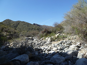
Hey Rocky, watch me pull some rocks out of my hat! by kingsnake  Sunset Pass is the 3884-foot pass between, to the west, Harquahala Mountain (5681 feet) and the Hill 5026 ridgeline, to the east. One would think that something labeled "pass" would have some sort of wagon-friendly, or at least horse-friendly, route for the hardy pioneer types to travel through in days gone past. If so, one would be wildly optimistic. Yes, there are 3+ mile jeep trails at either end, but the middle six miles are a whole different ball of burro poo. Sunset Pass is the 3884-foot pass between, to the west, Harquahala Mountain (5681 feet) and the Hill 5026 ridgeline, to the east. One would think that something labeled "pass" would have some sort of wagon-friendly, or at least horse-friendly, route for the hardy pioneer types to travel through in days gone past. If so, one would be wildly optimistic. Yes, there are 3+ mile jeep trails at either end, but the middle six miles are a whole different ball of burro poo.South Half Brown's Canyon Saddle, travels a similar route, five miles east, also with the middle third being wash / off-trail. However, the washes in Brown's are much more scenic, whereas here in Sunset they are just plain hard work. You are faced with a choice of beating across cactus and prickler-choked wash-crossed hillsides, or laboriously step-watching up rock-strewn Sunset Canyon itself. Long sleeves and pants, preferably of heavier material, are recommended. Also, stiff shoes to negate the effects of ankle-rolling. Otherwise, you will bleed. Guaranteed. Also, a week ago in Brown's, there were lots of pools; this week in Sunset there was no water of any sort. As Sunset is much harder work than Brown's, bring extra water, even in cooler months. Then, having beaten your way up Sunset Canyon, you are faced with the south wall of Sunset Pass: 700 feet in 0.6 miles. Not high, but steep, and after exhausting yourself on the way there.
TBD. The wash-walking is shorter and not as steep: If approached from the north, about 1000 AEG in 1.6 miles. This might be a better approach, but Gummo and I did not make it this far, so cannot say for sure. Check out the Triplog. Note This is a moderately difficult hike. Leave No Trace and +Add a Triplog after your hike to support this local community. One-Way Notice This hike is listed as One-Way. When hiking several trails on a single "hike", log it with a generic name that describes the hike. Then link the trails traveled, check out the example. | |||||||||||||||||||||||||||||||||||||||||||||||||||||||||||||||||||||||||||||||


