Route Editor

| Guide | ♦ | 2 Triplogs | 2 Topics |
details | drive | no permit | forecast | route |
stats |
photos | triplogs | topics | location |
| 35 | 2 | 2 |
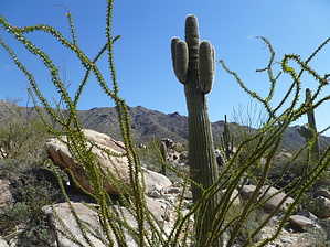
Prospecting Brown's1 by kingsnake  There are several different ways to approach Browns Canyon from the south, along Hwy 60. There are at least three major jeep trails: There are several different ways to approach Browns Canyon from the south, along Hwy 60. There are at least three major jeep trails:33.828432, -113.183839 33.81492, -113.18062 33.803973, -113.185899 As seen on this map I started on Microwave Relay Rd at 33.800086, -113.18864. The trails split, and join, and eventually converge maybe a mile below Brown's Canyon Dam. 4x4 recommended. If you have the vehicle, the further up you feel comfortable driving, the more time you have to explore Brown's Canyon Wash. Otherwise, from Microwave Relay Rd, it is about a four-mile hike to the dam. You don't need a GPS route -- I did not have one -- simply aim for the saddle west of Hill 4489 (the large mountain immediately west of Eagle Eye Rd). If you decide to go cross country, that is not a problem, as the ground is ankle-breaker and thigh-stabber free. The vegetation is mostly creosote and White Bursage, with a few brittlebush.
A half-mile northwest of the dam, just before Brown's Canyon proper, is a small triangular plateau that has the largest, greenest, most beautiful ocotillo you could ever hope to lay eyes on. There's a spring near the plateau, though I did not find it. Somewhere between a quarter and a half-mile past the plateau, if you look north, up the west slope of Hill 4489, you will see an amazing field of thousands of saguaro. Somewhere in that stretch, you need to begin bushwhacking your way up to the saddle. It will be much slower going than the first four miles of the hike, not only due to slope, but multiple wash crossings, numerous 2-3 foot rocks that need to be stepped up/around, and more paloverde, catclaw, and cactus than you can shake a hiking stick at. It will be slow going. Because I was hiking without a GPS route, I veered east of the saddle, about 200 feet higher up. From 3000 feet, I could easily see Gladden and the APS substation. From your high point, work your way north to the prospects, where you can pick up a jeep trail that four miles later will deposit you at the substation. There is a multi-acre corral about halfway between the prospects and the substation. From the corral north to Hwy 60, the road is easily traveled by a city car. If your shuttle driver parks at the corral you will save time for exploring / cut time off your hike. In summary, Brown's Canyon is well worth the time you spend in it! Note: The 'official' route is really just a guideline. Regardless of whether you do the hike south-to-north (as I did) or north-to-south, all you need to do is aim for the saddle. Check out the Official Route and Triplogs. Leave No Trace and +Add a Triplog after your hike to support this local community. | |||||||||||||||||||||||||||||||||||||||||||||||||||||||||||||||||||||||||||||||||||||