Route Editor

| Guide | ♦ | 9 Triplogs | 0 Topics |
details | drive | no permit | forecast | 🔥 route |
stats |
photos | triplogs | topics | location |
| 124 | 9 | 0 |
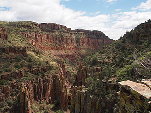
Deep canyon views and uranium mining history by Oregon_Hiker   Overview OverviewHighlights of this hike include stunning views of the Sierra Ancha including Aztec Peak, an old split rail corral on the plateau above the canyon, access to a seldom-visited deep and rugged canyon, and the site of the abandoned Donna Lee uranium mine. After a short (0.7 mile) hike on the easy-to-follow Deep Creek Trail #128, you will start the off-trail section to a long-abandoned mining road that enters upper Deep Creek canyon from a side draw about 1.5 miles upstream from where Deep Creek enters Bull Canyon. Upon entering the canyon the road turns down the canyon and is carved out of the rock for approximately 0.5 miles along the west wall of the canyon about halfway up from the canyon bottom. A side trail provides easy access to the creek bed below. The road leads to two abandoned mine shafts (adits) which were originally claimed in 1954 by the Miami Copper Co. According to the 1985 US Bureau of Mines report, "Mineral Investigation of the Sierra Ancha Wilderness and Salome Study Area, Gila County, AZ", 12 tons of ore were shipped from the mine in 1959. In 1978 the property was being explored by a joint venture between the Wyoming Minerals Corp. and the B and B Mining Company but the report makes no mention of additional ore removal other than that reported in 1959. The north mine shaft (adit) extended 90 feet into the canyon wall with a 52-foot long crosscut. The south adit extended 85 feet. These adits remain open but enter at your own risk. I chose to play it safe and did not enter them. Hike The hike starts at the Bull Canyon Trailhead at the blocked end of FR 203A on the boundary of the Sierra Ancha Wilderness. The drive up FR203A provides awesome views of the south side of the Sierra Ancha Mountains as well as distant views to both the east and west. This trailhead is the starting point for Deep Creek Trail #128 which you will follow north for 0.7 miles before turning east off-trail and passing through a barbed wire fence at an open gate (waypoint Gate 1). If you miss this gate there is another one (WP Gate 2) about 100 yds further up the trail. After passing through the gate, follow the GPS track across a somewhat level plateau which consists of relatively open grasslands with huge alligator junipers, patches of manzanita, some thorn bushes, and the random ground-hugging prickly pear cactus. The first destination is the large earthen Mesa Tank which on this trip was filled to the top with muddy water. Route finding due to the openness of this area could be done just by heading cross country to the tank waypoint with short detours around trees and brush patches or just heading due east from the "Gate 2" waypoint.
About 0.3 miles northeast of the corral the track turns northwest heading for an opening in the brush which leads to the start of a visible road grade at a barbed-wire fence. There is a gate in the fence at this location but do not pass through it. Turn north following the remains of the old roadbed which traverses the side of a draw as it makes a long arc turning to the east leading to Deep Creek. The roadbed soon becomes readily visible and you can put the GPS away except for finding the location of the path for a side trip to the creek bottom. The roadbed appears crude but some serious dynamite action must have been used to carve it out of the rock cliff walls - a very expensive and labor-intensive effort for the small amount of uranium extracted from these mines. The first adit is a short distance down the canyon and the second one is 0.3 miles further. The route along the old road provides fantastic views of the canyon walls and some tantalizing peeks into the canyon bottom. Although I did not see any dry waterfalls there most likely are a few to make hiking down the bottom an interesting adventure. Evidently, canyoneering folks frequent the lower section of Deep Creek from where it enters Bull Canyon down to Cherry Creek. I ran into a group preparing to do this route on my drive out of the area. The path to the creek bottom is a short distance down the old roadbed from its entry point into the canyon. The path leads off the road at an angle and could be mistaken for the road so checking the GPS track is recommended. I took this path, a couple of short steep switchbacks, to the creek on my return. The creek bottom downstream from the path is on a slab of slick bedrock for about 200 ft with small vertical steps and a trickle of flowing water forming shallow pools of water. Since it had just rained the day before I assume this creek bed would be dry most of the time except during periods of rain and snow. After the slick rock section, the stream bed is strewn with rocks up to 3 feet in diameter as far as I could see making it more difficult to proceed so that was my stopping point. Gate Policy: If a gate is closed upon arrival, leave it closed after you go through. If it is open, leave it open. Leaving a closed gate open may put cattle in danger. Closing an open gate may cut them off from water. Please be respectful, leave gates as found. The exception is signage on the gate directing you otherwise. Check out the Official Route and Triplogs. Leave No Trace and +Add a Triplog after your hike to support this local community. | |||||||||||||||||||||||||||||||||||||||||||||||||||||||||||||||||||||||||||||||||||||||||||||||||||||||||||||||||||||||||||||||||||||||||||||||||||||||||||||||||||||||||||||||||||||||||