Route Editor

| Guide | ♦ | 5 Triplogs | 0 Topics |
details | drive | no permit | forecast | route |
stats |
photos | triplogs | topics | location |
| 79 | 5 | 0 |
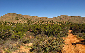
.. Peak 4 = The Highlight for Views .. by Grasshopper   Overview OverviewNorth of Globe, AZ, within the Tonto National Forest bordering the Salt River Canyon Wilderness and the Salt River, this recommended lollypop loop provides great high views with the opportunity to summit The Blackjack Mountains highest peak at 4851 feet and to summit via its connecting ridge-line, three (3) additional secondary peak summits at 4646 ft, 4797 ft, and the most scenic for distant views Blackjack Mountains peak #4 at 4831 feet. Warning Due to this typical high desert vegetation and high desert terrain altitude area "lack of shade" with only seasonal creeks/drainage's water flow, discretion should be considered for chosen month of visitation - "early winter to early spring recommended." Also, this 7.3-mile loop hike includes 3.1 miles of hiking in and out via a serious degraded old 4WD ranching route (unsigned FR986) and 4.2 miles of typical desert terrain "off-trail."
This hike begins at the base of Black Mountain 4515 and proceeds for 1.0 mile to an old ranching corral area, then continues down this degraded, unsigned 4WD route FR986 for a total of 1.2 miles before exiting this 4WD road west (a left turn) into a small wash drainage at waypoint coordinates 33.667201, -110.694877. Following the posted and recommend downloaded "official" GPS Route, will summit the Blackjack Mountains highpoint peak at 4851 feet (with a summit register) at 2.2 miles in with first distant high views SW, West, NW, and North to Yankee Joe Canyon, Salt River Canyon Wilderness, Salt River, the scenic White Ledges, the Fort Apache Indian Reservation, with distant views to the Sierra Ancha Wilderness (the Cherry Creek FR203 side). Continuing along the main Blackjack Mountains Ridgeline and following the "official" GPS Route will arrive at scenic views Secondary Peak Summit #2 (4646 ft) at 3.1 miles in.. a lovely location for a planned lunch break. Continuing along this ridgeline route will arrive at minimal views Secondary Peak Summit #3 (4797 ft) at 3.5 miles into this loop hike. Further along, this ridgeline route passing over Peak 3/Peak 4 Saddle Area and continuing to Peak #4 via following the west to north ridge will provide the real highlight views of this loop hike at Secondary Peak Summit #4 (4831 ft). Much closer and more majestic near and distant views of all the previously mentioned named areas a-top Blackjack Mountains highpoint peak 4851 feet are now viewable along this west to north end ridge of final Peak #4. Reversing the route over the highpoint for Secondary Peak Summit #4 to the Peak 3/Peak 4 Saddle Area at waypoint coordinates 33.681737, -110.700764 will be your loop route exit location SE for ~.83 miles to later intersect back with unsigned 4WD route FR986 at waypoint location 33.676008, -110.690752 . Please Note: This off-trail, mostly downhill, loose-rocky, with sometimes significant desert cactus vegetation route is the most difficult off-trail section of this entire 7.3 lollypop loop hike. Water Sources Seasonal Creek/Wash Drainages only. Camping Possible - Not Popular Check out the Official Route and Triplogs. Leave No Trace and +Add a Triplog after your hike to support this local community. | ||||||||||||||||||||||||||||||||||||||||||||||||||||||||||||||||||||||||||||||||||||||||||||