Route Editor

| Guide | ♦ | 2 Triplogs | 0 Topics |
details | drive | no permit | forecast | map |
stats |
photos | triplogs | topics | location |
| 22 | 2 | 0 |
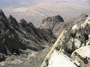
Shortest of the Big Ears by Jim  If you need greater detail to hike most of the way up what I previously, and erroneously, referred to as "Big Windy Canyon", please refer to my Rabbit Ears Plateau hike description. The correct name of the approach canyon is Rabbit Ears Canyon. Park at the trailhead, hike up the road to the Topp Hut, continue to the mine, proceed on the trail heading north towards Rabbit Ears Canyon, and hike, scramble, and gain most of the canyon. As your hike arcs gently southeast towards the Plateau-South Rabbit Ears saddle, pay attention to the large peaks to the north.
Despite how hard it may seem to ascend this gully, it is overall a reasonable scramble. At times, you will need to climb small faces, cross gravel slides, or go through the brush. I had to leave the gully a few times on descent, and you likely will as well. Just keep pushing on, and in 45 to 60 minutes, you should be very near the saddle. Once there, most of the effort is over. As you near the saddle, notice the fairly easy-to-climb rock on the right, or north side of South Rabbit Ear. Begin scrambling and climbing up this rock. I don't know what is the best route, but following what I did, make for the deep gully at the top of the easy rock and climb up that, heading east. A little beyond, you'll need to start to move south to the summit. You will have to get around some brush. None of the exposure is ever very great, and the rock is very good with many holds. The summit is marked with a rock pile. Celebrate 8,130' on South Rabbit Ear, and descend the way you came up. Be careful going down. I found this to be a little harder than what I have experience with in the Sierra and northern Rockies for scrambling, but that may be due to the brush. Overall, if you feel uncomfortable, you are probably off route, as this is entirely doable at class 3. There are numerous class 4 and easy 5th class routes on this peak, and this description serves as the descent route for them. Allow most of a day, avoid windy and lightning-prone days, and enjoy. Expect ice and snow in winter. Check out the Triplogs. Leave No Trace and +Add a Triplog after your hike & climb trip to support this local community. | |||||||||||||||||||||||||||||||||||||||||||||||||||||||||||||||||||||||||||||||||||||||||||||||||||||||||