Route Editor

| Guide | ♦ | 6 Triplogs | 0 Topics |
details | drive | no permit | forecast | route |
stats |
photos | triplogs | topics | location |
| 21 | 6 | 0 |
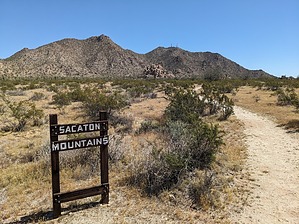
Paragon P1K Peak by pseudalpine  Overview OverviewAn endearing, cutesy, teddy-bear cuddling, off-trail peak loop readily accessed from the crème de la crème of Casa Grande's public space, North Mountain Park of Wainom Wo:g. This hike is wholly on the Gila River Indian Community but currently, there aren't posted no trespassing signs at this south side parking area. A possible other approach option is from the service road on the north side of this peak (via SR 387), where there are numerous no trespassing signs posted. Hike From the farthest north Ramada A, gap the fence and bear north following a sandy arroyo amongst some rocky outcrops. Eventually, you'll leave the wash and transect an old power line road that generally runs west/east at this point. Meander the road, for the most part east until the transmission lines turn southeast. Leave the cables and poles behind and continue mainly east across the rocky and wondrous Sonoran Desert until it's possible to enter the main wash that drains the southwest side of Sacaton Peak.
To finish the loop, descend abruptly northwest from the summit to access the road. Follow the dirt road west briefly and then continue across the boulder-strewn ridgeline. You'll cross over two significant rough crests and their accompanying saddles, then descend a west-facing ridgeline before sweeping sheerly south back down to the tortoise bajada lowlands. A bit more of open desert hiking to the south brings one back to the ramada parking near 1747. Synopsis A somewhat similar landscape as Joshua Tree National Park, but without the Yucca brevifolia, usually much hotter, a completely different desert, and also lacking the world-class climbing routes. So, it's nothing like the mecca of JTree, except that it's a highly jagged desert landscape. Note HAZ reminds you to obey all laws on certified signage. Check out the Official Route and Triplogs. Leave No Trace and +Add a Triplog after your hike to support this local community. | |||||||||||||||||||||||||||||||||||||||||||||||||||||||||||||||||||||||||||||||||||||