username
X
password
register
for free!
help
 
  🔥

Camp Grasshopper - Sierra Ancha FR235-C/Site#1, AZ

Guide 4 Triplogs  0 Topics
  4.3 of 5  
Fav
Wish
0
details
drive
no permit
forecast
🔥
route  
stats
photos
triplogs
topics
location
55 4 0
Statistics
tap row or icons for details
Trailhead Elevation 6,056 feet
unreported if dogs are allowed
editedit > ops > dogs to adjust
feature photo
Photos Viewed All MineFollowing
Inaugural Calculation on Button Tap!
9  2019-10-24
Explore Above GH Camp #1 - FR235
Grasshopper
38  2019-10-23 Grasshopper
7  2013-05-20 Grasshopper
10  2013-03-16
Sierra Ancha
mazatzal
Author
author avatar Guides 48
Routes 510
Photos 9,555
Trips 578 map ( 5,972 miles )
Age 79 Male Gender
Location Scottsdale, AZ
Historical Weather
Trailhead Forecast
Radar Map
Expand Map
Preferred Oct, Apr, May, Mar → 7 AM
Sun  5:59am - 6:46pm
Official Route
 
0 Alternative
 
Historic Fire Perimeteracres
🔥 2016 Juniper Fire30.6k


remove free decal offer
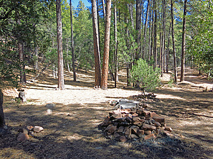
semi-shaded-area-roomy-remote-camp-spot
by Grasshopper

 
A nice oak and pine tree semi-shaded with clear ground areas-roomy-remote in-vehicle and/or flat tent campsite areas just off FR235 at 6,050 ft elevation with fire ring. Estimated 2-3 vehicles maximum. This vehicle campsite is 1.6 "four-wheel-drive" miles from the Billy Lawrence TH (at FR235 road end) and is also conveniently located for access to the 4WD-high clearance vehicle Reynolds Creek TH (located at FR410 road end).


2013-05-23 Grasshopper


    Check out the Official Route and Triplogs.
    Leave No Trace and +Add a Triplog after your car camp trip to support this local community.
    WARNING! Hiking and outdoor related sports can be dangerous. Be responsible and prepare for the trip. Study the area you are entering and plan accordingly. Dress for the current and unexpected weather changes. Take plenty of water. Never go alone. Make an itinerary with your plan(s), route(s), destination(s) and expected return time. Give your itinerary to trusted family and/or friends.

     Permit $$
    None


     Directions
    or
     Road
    Strictly 4x4

    To car camp trip
    From the Phoenix area- Take Hwy 60E to Globe (at MP247) turn north on HWY 188 towards Roosevelt Lake and drive 14.7 miles (at MP229.4) turn right onto HWY 288. Drive 27.6 miles north (at MP286.4) to FR410. Turn right on FR410 and continue for 2.2 slow & sometimes rough high clearance miles to FR410 intersection with FR235. Turn Left on FR235 and continue for a total of 3.1 slow & sometimes rough, rocky high clearance miles to a Left Turn into G/H Group Campsite #1 at 6050 ft elevation 33.866767 -110.93675. Also, see posted GPS Driving Route (from Hwy288/FR410) for review and download.
    page created by Grasshopper on May 23 2013 10:17 pm
     90+° 8am - 6pm kills
    helpcorrectionissue

    end of page marker