Route Editor

| Guide | ♦ | 4 Triplogs | 0 Topics |
details | drive | no permit | forecast | 🔥 route |
stats |
photos | triplogs | topics | location |
| 61 | 4 | 0 |
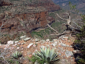
.. Main House & Outer Ruins from High Above .. by Grasshopper  Acknowledgement AcknowledgementThis author thanks HAZ members "Johnnie and glutz" for the first HAZ documented trip logs and photo sets from their successful exploratory hike on August 31, 2010, to this off-trail high plateau cliff overlook location to view Devils Chasm Cliff Dwelling- Main House and Outer Ruins. Without their postings, this author's successful visit on 5/16/13 and further documented herein for others to also enjoy would probably not have happened...Thank you!! Overview The "Devils Chasm Cliff Dwelling" is the most popular ancient cliff dwelling ruins site to visit in our Arizona- Tonto National Forest- Sierra Ancha Wilderness. Almost always accessed from the main Devils Chasm Canyon lower TH Start off Cherry Creek Road (FR203), this new view perspective of the entire cliff dwelling ruins site from 900 feet high above and across canyon beaming with afternoon sunlight is truly an awesome ~seven hundred-year-old ruin sight to behold.
Precautions should be considered for hiking during our Arizona monsoon-lighting season as well as during the warmer summer months due to high sun exposure for this out and back hike. Also, approximately .82 miles of this total 6.1-mile round trip hike is "off-trail" with route-finding ability necessary (Please Note: It is highly recommended to download and follow this hike's "official" posted GPS Route with all Key WPs included). Hike This out and back hike begins at the Moody Point Trail #140 Park/TH Start and proceeds on the trail in an easterly direction downhill for 1.46 miles to intersect Rim Trail #139. A left turn NE for only 0.1 miles and you will arrive at the second intersection of Rim Trail # 139 with Moody Point Trail #140. A left turn here (north) will put you on Trail #139. Continue straight ahead (east) on Moody Point Trail #140. You are now ~1.57 miles into this hike. Continue on Trail #140 for a total of 2.64 miles to the recommended "best off-trail exit point" NE... a left turn (at 33.804943 -110.878635 at 6642ft elevation). Continue following the official off-trail GPS route for an additional ~0.29 miles NNE to the Plateau Cliff Overlook (at 33.807875 -110.876204 at 6380 feet elevation) with stellar views down to Devils Chasm Cliff Dwellings- Main House and Outer Ruins. Reverse your route back and upon arriving at FR487- Workman's Creek Road, you may opt for a short hike and visit (included on the official GPS Route) to the Sierra Ancha Forest Service Work Cabin located only a short 0.17 miles right turn north on FR487. Check out the Official Route and Triplogs. Leave No Trace and +Add a Triplog after your hike to support this local community. | ||||||||||||||||||||||||||||||||||||||||||||||||||||||||||||||||||||||||||||||||||||||||||||||||||||||||||||||||||||