Route Editor

| Guide | ♦ | 1 Triplog | 0 Topics |
details | drive | permit | forecast | route |
stats |
photos | triplog | topics | location |
| 5 | 1 | 0 |
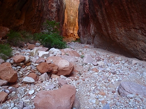
No cheating allowed by nonot  Overview OverviewA hike up a side canyon of Havasu Canyon Warning Do not enter any time rain is predicted or skies look threatening. Most of this canyon is a flash flood kill-zone. Also, you will need a Havasupai permit for this area, or you will get in deep trouble with the tribe if they find you. Note that statistics reflect only the lower canyon. It's about an extra 6 miles if you start from the Havasupai visitors campground.
Butchart reported on this, as did Benson, if I recall correctly. The earliest reported canyoneering description ever written was in Beaver canyon. Hike From the downclimb below Beaver Falls, cross and head up Havasu creek into the mouth of Beaver Canyon. In the very beginning, you will encounter Havasu creek water taking an alternate route around the small waterfalls, but the canyon will quickly dry up. You will quickly encounter some large boulders, and immediately after, a massive boulder with a 20 ft slick limestone upclimb. The easiest way past this obstacle is to backtrack 50 yards and climb around on the right (north), looking upcanyon. The bypass goes very easy, and soon you will be back in the canyon bed navigating up gravel and many boulders. This goes on another half mile with several short bouldering climbs. After this, the bed flattens, and you will encounter a short section of flowing water from Beaver Springs. Above Beaver springs, it alternates between flat and more boulders. There is a little bit of vegetation near Beaver springs, but above, you enter into a flash flood scoured canyon. As you near a junction, the main fork of Beaver canyon bends to your left, and the canyon narrows dramatically. Here you encounter mostly gravel and may get out of the sun since it is narrow, and about 150 ft tall walls surround you. As you keep going, you near the top of the Redwall, but before you get there, you will encounter the final obstacle of your hike - about a 20 ft tall chockstone that blocks the canyon wall to wall. This is the end of the hike. Previous reports suggest there is a hole you can use. That hole may have existed, but the latest (or earlier) flash flood had jammed any possible holes with sand and a large amount of vegetative debris upon inspection. Right now, it appears there are two options: a 5.9 looking off-width climb making use of a small chockstone to the left, or to try to reopen the hole by digging out the sand and debris. I was out of time ( 5 minutes past my self-negotiated "postponed" turnaround deadline), so I didn't attempt either. Coming down from above canyon seems easier (jump about 8 ft from the small chockstone jammed to the side of the big one), but reversing the route will take significantly more effort nowadays. Per Harvey's words, "the inexpert climber will struggle to get back up." I wish I had the time to attempt the climb - it looks harder now than Harvey described, but perhaps it isn't as bad as it seems. What makes it difficult now is that all the sand at the base of the boulder is scoured away, making it 3-4 feet deeper at the big chockstone base. So the first reasonable handhold is almost out of reach. Note: if you can get by this chockstone, it is reportedly easy to get into Little Coyote where other routes exist. This author has yet to confirm this in person, but I don't expect any other significant problems. Water Sources Beaver spring appears reliable. It didn't taste salty from a few sampled drops, but springs in this area are notorious for being highly mineralized. Camping Not in this area. Check out the Official Route and Triplog. Leave No Trace and +Add a Triplog after your hike to support this local community. | |||||||||||||||||||||||||||||||||||||||||||||||||||||||||||||||||||||||||||||||||||||