Tumamoc Hill, AZ | HikeArizona
username
X
password
register
for free!
help
 

Tumamoc Hill, AZ

Guide 2,647 Triplogs  0 Topics
  2.6 of 5 
Fav
Wish
3
details
drive
no permit
forecast
route  
stats
photos
triplogs
topics
location
97 2.6k 0
HAZ reminds you to respect the ruins. Please read the Archaeological Resources Protection Act of 1979 & Ruins Etiquette
Statistics
tap icons for details
Popular Workout
Difficulty 1.5 of 5
Route Finding 1 of 5
Distance Round Trip 2.9 miles
Trailhead Elevation 2,371 feet
Elevation Gain 730 feet
Accumulated Gain 750 feet
Kokopelli Seeds 6.65
 Interest Ruins, Historic & Peak
 Backpack No
 Dogs not allowed
feature photo
Photos Viewed All MineFollowing
Will recalculate on button tap!
3  2023-02-21 azbackpackr
1  2022-10-15 Pivo
1  2022-05-09 Pivo
1  2022-04-18 Pivo
1  2022-04-15 Pivo
7  2022-03-19 chumley
3  2021-04-18 HikerWill
1  2020-07-15 Pivo
Page 1,  2,  3,  4,  5
Author
author avatar Guides 28
Routes 20
Photos 672
Trips 169 map ( 1,088 miles )
Age 45 Male Gender
Location Old Pueblo
Associated Areas
list map done
Tucson Region
Historical Weather
Trailhead Forecast
Radar Map
Expand Map
Preferred Feb, Oct, Nov, Dec → 5 PM
Seasons   Early Autumn to Late Spring
Sun  6:51am - 6:22pm
Official Route
 
3 Alternative
 
 Water


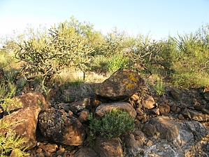
Short but sweet...
by Jeffshadows

Background
Tumamoc Hill is home to the University of Arizona's Desert Laboratory since its inception in 1903 under the direction of the US Department of Agriculture. Centuries earlier, the hill was home to the Hohokam and remains a cherished archaeological site due to some of the unique features its previous inhabitants left behind. According to the University of Arizona: Tumamoc Hill, occupied between 300 BC and AD 450, is one of only a handful of trincheras, or terrace hillside sites, in the Sonoran Desert. Its features include terraces, walls, petroglyphs, trails, bedrock mortars, and approximately 150 small, circular pit structures. Also present are several rocks adorned with petroglyphs. However, be aware that these sites are closed to the public, and few are visible from the path. Today, continued access to Tumamoc is in jeopardy due to off-trail travel and general disrespect for usage guidelines.


Hike
The path to the summit of Tumamoc Hill is a paved road, and I choose to include it on HAZ for completeness sake, as much as the fact that it provides fantastic views of the Tucson valley and Sentinel Peak. Additionally, Tumamoc is a great afternoon or early morning workout destination for a quick jaunt into the pristine desert. It is located near enough to most Tucsonans to provide a real opportunity for such activity. The path is a popular destination for walkers and trail runners. Please note that the path is off-limits between the hours of 0730 and 1730 on weekdays to protect research activities. Additionally, visitors should understand and respect the strict policy forbidding off-path travel. The area and the research it supports are sensitive, and the study is over a century old.

The path leaves Anklam road and passes a set of pipe gates, which may or may not be unlocked. They may be bypassed to the left. The path heads due south into the Tucson mountains. After a short distance, it begins its pattern of long switchbacks, which become progressively steeper. The views of the Tucson valley and the mountain ranges beyond gradually becomes broader, as well. After a mile, the path approaches a series of basalt stone buildings that look as though they should be transplanted into Tucson's Armory Park district. Another gate is encountered here and is also likely to be locked. Walk around to the right. The switchbacks become steeper for the final half-time into the crest. Despite being populated with radio towers and shacks, the views from the summit are sweeping and make you immediately forget the fact that you just walked up a road. Return the way you came.

Check out the Official Route and Triplogs.

Gate Policy: If a gate is closed upon arrival, leave it closed after you go through. If it is open, leave it open. Leaving a closed gate open may put cattle in danger. Closing an open gate may cut them off from water. Please be respectful, leave gates as found.

Leave No Trace and +Add a Triplog after your hike to support this local community.

2008-09-05 Jeffshadows
  • sub-region related
WARNING! Hiking and outdoor related sports can be dangerous. Be responsible and prepare for the trip. Study the area you are entering and plan accordingly. Dress for the current and unexpected weather changes. Take plenty of water. Never go alone. Make an itinerary with your plan(s), route(s), destination(s) and expected return time. Give your itinerary to trusted family and/or friends.

 Permit $$
None


 Directions
or
or
 Road
Paved - Car Okay

To hike
From anywhere in Tucson, get to Speedway Blvd. and follow it west to Silverbell road. Briefly take Silverbell south and turn right onto Anklam Street. The trailhead is immediately south and is marked by a large green sign identifying it as the path to the "Desert Laboratory." A few parking spaces have been provided along Anklam.
page created by Jeffshadows on Sep 05 2008 9:24 pm
helpcorrectionissue

end of page marker