Route Editor

| Guide | ♦ | 2 Triplogs | 0 Topics |
details | drive | permit | forecast | route |
stats |
photos | triplogs | topics | location |
| 21 | 2 | 0 |
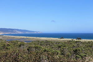
Hike an environmental success story by JimmyLyding  Reyes History: 53 years ago some very wise people fought hard to successfully preserve the area after a 900-home subdivision was planned. Indeed the conventional wisdom of the time was that western Marin County would become as densely-populated as its eastern counterpart. Local conservationists enlisted the help of California Congressmen Clem Miller and Clair Engle to further their case to preserve the area for future generations to enjoy. Secretary of Interior Stewart Udall supported the idea of turning Point Reyes into a National Seashore, and today we are all richer because these wise men.
The terrain here has rolling hills toward the coast and ridges heading 1,000' and 2 miles up to the top of Inverness Ridge to the north. It's easy to envision a large housing development here. It would've been such a nice place to live, and maybe Hwy. 1 would've been widened to 6 lanes in order to funnel all of the traffic into and out of the area. However, there were some wise men who thought such a vision of Point Reyes wasn't the wisest choice. Many of us know about the great Arizonan, Stewart Udall, but not many know about Congressmen Engle and Miller who are just 2 of many people who helped preserve what we have left. Urban and suburban development was the norm in 1962 when they introduced a bill to create the National Seashore. Engle is perhaps best known for pointing to his eye during a vote for cloture (to end a filibuster) during a roll call for voting on the Civil Rights Act of 1964 to signal "aye" because he was unable to speak due to the brain tumor that would end his life a month later at the age of 52. Congressman Clem Miller was perhaps the main driving force behind the creation of Point Reyes National Seashore. He warned "we will leave our children a legacy of concrete treadmills leading nowhere except to other congested places like those they will be trying to get away from." Amen. Miller, like Engle, passed too soon. He died in a plane crash in 1962 at the age of 45. He is buried at Point Reyes National Seashore to forever look after the place he helped preserve. These were just 2 of the many people who felt a need to preserve the wild places we had left, and it's easy to remember them as you meander down a trail festooned with the same poison oak and blackberries that thrived 100 years ago. The hike crosses a small dam holding back a shallow reservoir almost 3 miles in. One second you're hiking through the gentle coastal hills, and the next there's a lake on the right. It's probably for cattle judging by the fact there's a gate on the west side of the dam warning that the area to the north and west are reserved for the Drakes Bay Cattle Ranch. The route turns south on the White Gate Trail to follow a drainage down towards Estero de Limantour past a larger reservoir that lies just above a good-sized wetland at the head of the estuary. This is cattle country, and indeed the area's cattle ranchers and dairy farmers were pivotal in the fight to create Point Reyes National Seashore. They rightly feared for the loss of their livelihoods with the creation of the National Seashore, and organized to make their voices heard. At the time western Marin County was largely devoted to beef and dairy, and folks knew that their way of life was in danger due to either preservation or suburban development. In the end there was a compromise that allowed a certain level of ranching and dairy production while adding another piece to the National Park system. A huge upshot of the ranchers' organization was that many large parcels of western Marin County were preserved rather than paved over because the ranchers' newly found political power proved to be a potent force as our nation was only beginning to understand that progress did not always mean pavement. The hike continues along the western shore of the larger reservoir for about a mile to a junction with the Estero Trail. The spectacular views towards the coast really open up during this stretch, but it's pretty obvious that this area has been heavily grazed. The trail disappears in a moonscape just before it heads down to cross over the dam, but it's not too difficult to figure out the right direction: just head for the earthen dam. The trail crosses the dam, and immediately enters a 3/4-mile stretch through thick brush. Unfortunately much of this brush is poison oak and stinging nettle. It's not very cool, but just deal with it. Also, don't wear shorts on this one as I did. The Estero Trail climbs out of the brush to the top of a small ridge that leads down to the Limantour Estuary, and the trail follows it gently down to the coast. The views were nice before, but they really get cool here. The actual Point Reyes and its hills lie a few miles to the southwest, Mount Vision is to the north, and Mount Wittenberg is due east providing great views. The terrain here shifts from coastal scrub to coastal grassland, and grazing elk are common in the area. The route heads due south from a junction with the Glenbrook Trail about 1.25 miles from the dam keeping on the Estero Trail. The views are great here as the trail sticks to the top of the ridge before doubling back down to the next drainage to the east. Some eucalyptus trees make an appearance here, and they add a bit of color even if they're introduced exotics. The Estero Trail runs 4 miles from the Glenbrook Junction, and the last portions are a decent downhill stretch through a dense Bishop pine forest to the Muddy Hollow drainage before a short 1/2 mile stretch back to the trailhead. As you return to your vehicle you may marvel at the notion that Congressmen and ranchers worked together to preserve one of the nicest places in the country. You may notice horse trailers, Subarus, Volvos, hippies and yuppies at the trailhead, and realize that everyone won here. Gate Policy: If a gate is closed upon arrival, leave it closed after you go through. If it is open, leave it open. Leaving a closed gate open may put cattle in danger. Closing an open gate may cut them off from water. Please be respectful, leave gates as found. The exception is signage on the gate directing you otherwise. Check out the Official Route and Triplogs. Leave No Trace and +Add a Triplog after your hike to support this local community. | ||||||||||||||||||||||||||||||||||||||||||||||||||||||||||||||||||||||||||||||||||||||||||||||||