 Route Editor

| Guide | ♦ | 6 Triplogs | 0 Topics |
details | drive | no permit | forecast | route |
stats |
photos | triplogs | topics | location |
| 0 | 6 | 0 |
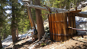
 We started at the Aspen Loop to "AZT#34 - San Francisco Peaks". Start off-trail by the "Snowmobiles forbidden in the Wilderness" sign. It follows an old, barely visible (in spots) two-track until it reaches the woods and starts climbing. In the woods, the route is cairned and gets considerable game traffic. Follow cairns to the end, or do like we did and follow to the metal pipe and on to the spring. The first stop is an old wooden water catchment. Then up the scree SE to the water catchment (0.2 miles) away and the end of the pipe. Actual Spring is 100' to the NE of the Catchment. We started at the Aspen Loop to "AZT#34 - San Francisco Peaks". Start off-trail by the "Snowmobiles forbidden in the Wilderness" sign. It follows an old, barely visible (in spots) two-track until it reaches the woods and starts climbing. In the woods, the route is cairned and gets considerable game traffic. Follow cairns to the end, or do like we did and follow to the metal pipe and on to the spring. The first stop is an old wooden water catchment. Then up the scree SE to the water catchment (0.2 miles) away and the end of the pipe. Actual Spring is 100' to the NE of the Catchment.
Check out the Official Route and Triplogs. Note This is a difficult hike. Arrive fit and prepared or this could get ugly. Leave No Trace and +Add a Triplog after your hike to support this local community. One-Way Notice This hike is listed as One-Way. When hiking several trails on a single "hike", log it with a generic name that describes the hike. Then link the trails traveled, check out the example. | |||||||||||||||||||||||||||||||||||||||||||||||||||||||||||||||||||||||||||||||||||||||||||||||||||||||||||||||||||||||||||||||||||||||||||||||||||||||||||||||||||||||||


