| Guide | ♦ | 2 Triplogs | 0 Topics |
details | drive | permit | forecast | map |
stats |
photos | triplogs | topics | location |
| 0 | 2 | 0 |
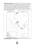
The easiest way to access this trail is to begin at the Wahtum Lake Trailhead and drop down to the Pacific Crest Trail #2000. Go east around the lake on #2000 and loop west up to the junction with the Herman Creek trail #406 and shortly afterward, the Chinidere Mountain Trail #445. This way is about 1.8 miles to the beginning of this trail from the Wahtum Lake Trailhead. A slightly shorter way to access this trail also starts at the Wahtum Lake Trailhead. From here drop down to #2000 and go west 0.2 miles. Then follow the Eagle Creek Trail 0.1 mile to the lake’s outlet and go north up the Chinidere Cutoff Trail #406M 0.1 mile to #2000. Follow #2000 300’ west to the beginning of this trail. This route is steeper. Once at the Chinidere Mountain Trail #445, head northwest up several short switchbacks. The trail is easy to follow, and moderately steep. In only a half mile you are standing on one of the best summits around. Check out the Triplogs. Leave No Trace and +Add a Triplog after your hike to support this local community. One-Way Notice This hike is listed as One-Way. When hiking several trails on a single "hike", log it with a generic name that describes the hike. Then link the trails traveled, check out the example. | |||||||||||||||||||||||||||||||||||||||||||||||||||||||||||||||||||
 Route Editor


