|
tap row or icons for details
|
| Difficulty |
|
3 of 5 |
| Distance One Way |
|
3 miles |
| Trailhead Elevation |
|
12,104 feet |
| Avg Time One Way |
|
2 hours | | Backpack No | | unreported if dogs are allowed
editedit > ops > dogs to adjust |
| | |
|
|
13 |
2018-09-23 | sneakySASQUATCH |
|
|
150 |
2015-09-20 |
Colorado Fall Colours - Sep2015 |
Randal_Schulhaus |
|
|
|
15 |
2013-07-19 | blueberry1222 |
|
| |
|
|
|
list |
map |
done |
Northwest Region |
| | |
|
| |
|
|
Historical Weather |
| Trailhead Forecast | | |
|
 |
|
|
| Preferred Jul, Aug, Jun, Sep → 9 AM |
|
|
|
Seasons Late Spring to Early Autumn |
|
|
| | |
| |
Named Locations Coordinate Links
| |
|
| help future hikers |
| post a gps route now |
| | |
| |
|
|
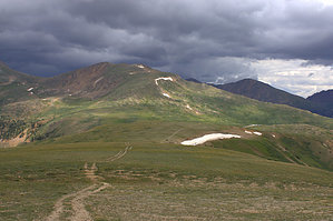
 Beautiful hike on the Continental Divide. Independence Pass is located on the drive between Leadville and Aspen. There is a hiking path straight from the parking lot at 12,095 feet. There are two trail options: Concrete user friendly trail or dirt path leading up to one of the ridges. I would recommend the dirt trail along the tundra. Of course, stay on the trail and resist the urge to wander off onto the fragile tundra where plants take 20 years to take root. Enjoy the landscape that was sculpted by glaciers thousands of years ago. And of course, keep an eye on the clouds as they move fast up here and weather changes on a dime. Independence Pass used to be part of the territory of the Ute Indians. It used to be that Colorado settlers were ordered to settle only in areas east of the Continental Divide, but gold was found in them thar hills, and prospectors set up camp all over the place, defying all orders to the contrary. The road was needed to get to the precious metals. One-Way NoticeThis hike is listed as One-Way. When hiking several trails on a single "hike", log it with a generic name that describes the hike. Then link the trails traveled, check out the example. |
 Route Editor


