Route Editor

| Guide | ♦ | 24 Triplogs | 1 Topic |
details | drive | no permit | forecast | 🔥 route |
stats |
photos | triplogs | topic | location |
| 357 | 24 | 1 |
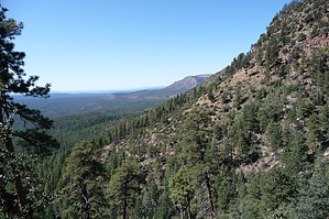
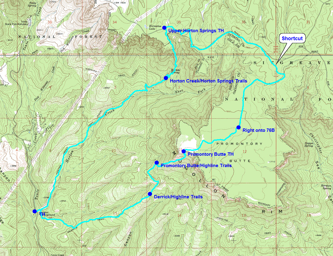
More pain, more gain by gpsjoe  Most local hikers are aware of the Derrick-Highline-Horton Creek loop hike (see HAZ hike description). It's 8 miles of mostly good trail and is rated as moderate (level 3). Hiking groups do this loop frequently. The Horton Super Loop adds distance, elevation, and 2 miles of tortuous trail to this loop making it a 4.5 level hike. Most local hikers are aware of the Derrick-Highline-Horton Creek loop hike (see HAZ hike description). It's 8 miles of mostly good trail and is rated as moderate (level 3). Hiking groups do this loop frequently. The Horton Super Loop adds distance, elevation, and 2 miles of tortuous trail to this loop making it a 4.5 level hike.The total loop is 14 miles and is a curious mixture of 12 miles of easy to moderate trail (mostly easy) and 2 miles of very difficult trail. I started from the Horton Creek trailhead and hiked the usual route to the intersection of Horton Creek trail (285) and the Highline trail (31). I crossed the Highline trail and hiked the Horton Springs trail (292), a backdoor way of getting to Horton Springs. There I had trouble finding where the Horton Springs trail continued until I found the 2 small cairns.
Turn right on Rim road and hike the road for about 2 miles. The rim is near the road in the first mile so I wandered over to the rim a few times to take in the views. Around the point shown on the map, I did some easy cross-country hiking over to FR76, the main road going off of Rim road out on the Promontory Butte. You could stay on Rim road to FR76 but the shortcut is better I think. I made the mistake of going off Rim road too early (twice) and was forced back out because the terrain was too difficult there. These mistakes were edited out of the map shown and the GPS route I submitted. Hike FR76 to the point indicated on the map and turn right there. FR76 continues and is the main road. The right is onto FR76B and is unsigned. It goes directly to the rim of the Butte and the Promontory Butte trailhead. This is a great place to drop your pack, park on a rock on the rim, enjoy the views, and have lunch. Now you are in for 3/4ths mile of hiking hell. The Promontory Butte trail drops 1,150 feet in 3/4ths mile. It is soft earth and loose rocks mixed in with the steepest of slopes and lots of deadfalls to make matters worse. There are a number of sucker trails (they look like trails going down but are not the real trail) so pay attention and keep that swiveling head going 360 degrees at all times. Not many hike this one, maybe for good reason. It is scary in spots. This is level 5 hiking so hikers beware. If you don't think you can handle this, don't go. When you reach the Highline trail your troubles are over, the rest is easy. Turn left on Highline for less than a mile to the intersection of the Highline and Derrick trails where there are two posts but no signs. Going straight puts you on the Derrick trail (you have to turn left to stay on Highline). Hike the Derrick trail (a little rocky in spots) back to the campground and onto your car at the Horton Creek trailhead. Four Mogollon Rim loops: See Canyon - Promontory Butte loop [View Route] is 13.5 miles with a difficulty rating of 4. Starts from the See Canyon trailhead. See Canyon - Drew loop [View Route] is 11 miles (12 with a side trip to See Spring) with a difficulty rating of 3.5 Also starts from the See Canyon trailhead. HAZ member Kanode originally submitted a route for this hike containing a side trip to See Spring. I submitted a route without the side trip that is only slightly different from Kanode's. Either route will work fine. Sinkhole - Drew loop [View Route] is 12 miles with a difficulty rating of 3.5. This is the Mogollon Rim Vista Loop described in my HAZ write-up. Starts from the 260 trailhead. Horton - Promontory Butte loop [View Route] (above) is 14 miles with a difficulty rating of 4.5. Starts from the Horton Creek trailhead and is described in the above write-up. The difference in the difficulty ratings for these loops is determined in large part by the difficulty of the trail that goes up to the rim. These are the Horton Springs Trail - 4, Promontory Butte Trail - 5 (hikers beware!!!), and See Canyon & Sinkhole Trails - 3. I have submitted GPS routes for all of these loops. The routes are most useful for the hike between trailheads on top of the rim. It is not obvious how to get from one trailhead to another on top and you will want these routes loaded on your GPS or printed maps showing the routes. Gate Policy: If a gate is closed upon arrival, leave it closed after you go through. If it is open, leave it open. Leaving a closed gate open may put cattle in danger. Closing an open gate may cut them off from water. Please be respectful, leave gates as found. The exception is signage on the gate directing you otherwise.
Check out the Official Route and Triplogs. Note This is a more difficult hike. It would be unwise to attempt this without prior experience hiking. Leave No Trace and +Add a Triplog after your hike to support this local community. | |||||||||||||||||||||||||||||||||||||||||||||||||||||||||||||||||||||||||||||||||||||||||||||||||||||||||||||||||||||