 Route Editor

| Guide | ♦ | 6 Triplogs | 0 Topics |
details | drive | no permit | forecast | 🔥 route |
stats |
photos | triplogs | topics | location |
| 15 | 6 | 0 |
It's not the destination, it's the journey. by PrestonSands   Overview OverviewThis hike follows what is known as the "Blackjack Trail" (trail #568), and its spur trail #568A, from Blackjack Campground to a little hilltop overlook in Arizona's Big Lue Mountains. If you are camping in the area, this hike makes for an easy outing. If you are looking for something more adventurous, it should be possible to connect with the 8345 trail in Coal Creek Canyon, roughly a 1.5-mile off-trail journey to the northeast from the end of this hike (study a topo map first). Although this hike follows a road and ATV trails, it is highly unlikely that you will encounter anyone else in this out of the way place. Hike The hike begins at the Blackjack Campground, along highway 78. About 500 feet east and directly across from the campground entrance is a spur road that passes through an opening in the barbed wire fence, near a large dirt pile. This is mile 0.0 for this hike. Although unmarked, this is trail #568 (Blackjack Trail). Park at the campground, and start following the road (trail 568), after passing through the barbed wire fence. After passing a cattle pond, the road makes a sharp bend to the right and reaches a pass among the tall pines. The road rapidly deteriorates into a lightly used ATV trail when it drops down the pass's east side.
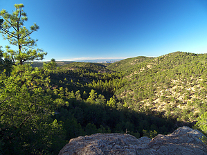
Trail 568A now heads south along the rocky spine of a ridge that offers views of the surrounding wooded canyons and comes to a rain gauge/weather station tower at 1.1 miles. At this point, the trail becomes a bit more primitive but is still readily apparent. Turning southeast to continue along the rocky ridge, the trail crosses a saddle and passes a nice viewpoint ledge on the north side of a rounded hill, before reaching another saddle at 1.3 miles. At this saddle, our trail makes a left (northeast), climbs briefly, and reaches an open hilltop overlook at 1.4 miles. At this spot, one can enjoy 360-degree views of Maverick Hill, the Big Lue, and White Mountain ranges, and New Mexico's towering Mogollon Mountains. A vague path does continue east from the hilltop along the gentle ridge, but it peters out within a quarter-mile. Return the way you came. Check out the Official Route and Triplogs. Leave No Trace and +Add a Triplog after your hike to support this local community. | |||||||||||||||||||||||||||||||||||||||||||||||||||||||||||||||||||||||||||||||||||||||||||


