Route Editor

| Guide | ♦ | 12 Triplogs | 0 Topics |
details | drive | no permit | forecast | 🔥 route |
stats |
photos | triplogs | topics | location |
| 94 | 12 | 0 |
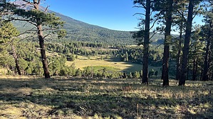
Cinder a Letter by NitroTheWolf  Overview OverviewWalker Lake Cinder Cone is a great beginner hike for those who are interested in hiking one of the many cinder cones in the Flagstaff Area. With an average of 350 feet of elevation gain, it's a great hike for those looking for an easy hike in the area. Walker Lake Cinder Cone has an elevation of 8911 feet and contains a summit log at this high point. Hike From the closed road sign, which is where it is recommended to park, head up along the road until you reach the rim. Once here, you have the choice to go either clockwise or counterclockwise. Heading counter-clockwise is less steep than heading up. The rim trail might be difficult to spot from the closed road, but as long as you follow the rim, you shouldn't have any issues locating it. As you follow the rim trail around, there's the summit log at the high point on the northern side. It's a small spice jar, covered with rocks. There's a trail heading down into the bowl of the cinder cone near the end of the closed road. If you're lucky, you might see a few deer or elk drinking from Walter Lake. Return to you're vehicle via the same closed road you hiked up.
Walker Lake in the bowl of the cinder cone usually has water. Make sure to bring a way to purify it (LifeStraw, tablets, boiling, etc.) Camping Camping is allowed in the surrounding area and on Walter Lake Cinder Cone. However, there's a fair amount of private property in the area; heed all no trespassing signs and double-check a parcel map before picking a spot. Check out the Official Route and Triplogs. Leave No Trace and +Add a Triplog after your hike to support this local community. | |||||||||||||||||||||||||||||||||||||||||||||||||||||||||||||||||||||||||||||||||||||||||||||||||||||||||||||||||||||||||||||||||||||||||||||||||||||||||||||||||||||||||||||||||||||||||||||