Route Editor

| Guide | ♦ | 16 Triplogs | 0 Topics |
details | drive | no permit | forecast | route |
stats |
photos | triplogs | topics | location |
| 72 | 16 | 0 |
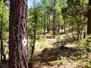
 The trail follows Billy Creek and winds its way through a ponderosa pine forest to the top of Blue Ridge Mountain. The mountain is volcanic in origin and its summit offers scenic vistas of the area. Portions of the trail follow old logging roads. Connector trails head southeast to Springs Trail and northwest to Ice Cave Trail #608. The trail follows Billy Creek and winds its way through a ponderosa pine forest to the top of Blue Ridge Mountain. The mountain is volcanic in origin and its summit offers scenic vistas of the area. Portions of the trail follow old logging roads. Connector trails head southeast to Springs Trail and northwest to Ice Cave Trail #608.Lined with large ponderosa pines the trail winds along Billy Creek and ascends Blue Ridge Mountain. Because of the area's volcanic origin, parts of the trail are pretty rocky and may be challenging for bikers. Bring a map - There are Forest roads and other trails close by that may be confusing, especially to those that are not familiar with the area. Check out the Official Route and Triplogs. Leave No Trace and +Add a Triplog after your hike to support this local community. | ||||||||||||||||||||||||||||||||||||||||||||||||||||||||||||||||||||||||||||||||||