 Route Editor

| Guide | ♦ | 7 Triplogs | 0 Topics |
details | drive | no permit | forecast | route |
stats |
photos | triplogs | topics | location |
| 125 | 7 | 0 |
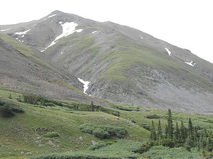
Eat your Wheaties by rvcarter A loop could be made of the Belford climb by returning via Elkhead Pass and down the gulch, but it is somewhat longer and I wanted to get down the mountain as soon as I could because of the weather. I didn’t even eat lunch till half way down. The very-easy-to-follow trail to Belford is comprised of three distinct sections. The first part (the lower section is actually called the Missouri Gulch Trail and continues to Elkhead Pass) is along the creek that flows down to the trailhead through a canopy of pine/fir trees. There is lots of running water and continuous sound from that water along the way. Near the top of this section just short of the treeline is where lots of backpackers make camp for an easier climb to the peaks. The only thing you need to watch for, especially after big rains, is the impromptu log/branch/twig crossing of the creek. The second part (starting just before where the trail splits for Belford and Missouri Mountain) is relatively gentle and takes you to the base of Belford (about 12,000 feet), passes through an explosion of Columbine and other wildflowers, and lots of wetland willows at and just above the tree line. This area is a photographer’s heaven. The third part is what you ate your Wheaties for earlier. It is an endless (nearly) series of steep switchbacks on an exposed ridge that is a knee killer on the way down (and I forgot my hiking poles). This 2100+ foot part is slow and hard, and it will suck your heart out (you lost your lungs a bit earlier). The relatively large Missouri Gulch Trailhead was full when I arrived after 7:00 a.m., but there was plenty of free parking along the road. Surprisingly, I encountered very few people on the lower half of the trail. There were a few dozen near the top, but not the huge number I expected on a weekend day.
Endnote: highly recommend the National Geographic Trails Illustrated Map 129, “Buena Vista Collegiate Peaks” for planning and navigation. Check out the Official Route and Triplogs. Leave No Trace and +Add a Triplog after your hike to support this local community. One-Way Notice This hike is listed as One-Way. When hiking several trails on a single "hike", log it with a generic name that describes the hike. Then link the trails traveled, check out the example. | ||||||||||||||||||||||||||||||||||||||||||||||||||||||||||||||||||||||||||||||||||||||||||||||||||||


