Route Editor

| Guide | ♦ | 7 Triplogs | 1 Topic |
details | drive | no permit | forecast | 🔥 route |
stats |
photos | triplogs | topic | location |
| 96 | 7 | 1 |
Canyons are inherently risky. Flash floods occur without notice on sunny days. Technical skills & surrounding topography knowledge required yet does not eliminate risk.
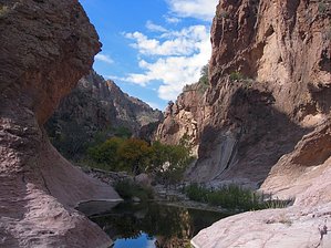
Easy? ...sounds fishy by nonot  Overview OverviewThis trip description covers the upper half of Fish Creek from its start on Frog Tanks Trail #112 to the bridge over the canyon on Apache Trail. Reaching the upper portion at Frog Tanks will likely take you most of a day using various hiking options. A loop with the JF trail will weigh in at about 22 miles, not counting walking or hitchhiking the Apache Trail itself. In November of 2008, this canyon has one obstacle that makes the overall rating of the canyon class 2. If members of your party wish to swim in rather chilly waters with their gear, then you could rate this as a class 1 canyon.
Fish Creek Canyon is a physically challenging route when done in a single day, even when done top to bottom. A flash flood significantly changed this canyon between 2006 and 2008. In places where there used to be trees, there are no trees and 15-foot piles of sand. The social trail in the last mile to the bridge was significantly worsened as well. So, please stay out of this canyon if any significant rains are predicted anywhere in the area. Fish Creek drains a large majority of the west-central Supes and can carry huge volumes of water. If bringing children, they need to be practiced in bouldering skills as there are several climbing obstacles, and given the size of the boulders, it will be even more difficult for those who are height-challenged. History Fish Creek Canyon is a reasonably reliable water source in the northern Superstitions. The presence of multiple ruins along the creek shows that the Salado Indians made use of this land. Unfortunately, the obvious settlements have been mostly destroyed by vandals. Hike Starting from Frog Tanks, Fish Creek cuts west where drainages from Angel Basin, Rough Canyon, and Paradise Canyon merge on their route to the lake. For the first half-mile, the scenery is spectacular. Arizona sycamores line the creek, and the going is rocky but flat. Water is frequently seen, some spots better than others. About a half-mile in from the top is the most challenging section of the entire canyon. Smooth rock walls tower on either side of you, and the canyon narrows. The creek funnels into a slickrock slot, which has a significantly deep water pool that spans the canyon side to side. Not wanted to take a chilly swim and drag heavy water-laden packs the rest of the way, the best (though not recommended) way to get around is to climb 50 feet to a gap in the tower on the left, looking down canyon, and shimmy/slide down a 70-degree slope on the other side. The right side (looking down canyon) has cliffs near the top the prevent progress. Once past this section, the canyon resumes its relatively gradual slope downstream. The going is slow but steady, and one can marvel at the numerous caverns carved by the wind and water, making sections of upper Fish Creek look like Swiss cheese. There is little overgrowth to worry about when the water is low, so we continue down canyon, hopping on the larger rocks. After 4 miles of this enjoyable torture, the canyon opens up as Lost Dutch canyon joins from the south. Here, the creekbed turns to smaller gravel, and it is extremely open and flat for the next mile. This section could get quite warm as it has little shade and lots of sun exposure. Gradually, the canyon narrows and rock-hopping will start to get more difficult. At 5 miles in, there are numerous enormous boulders, some bigger than houses, that obstruct the creekbed. This section will wear you out as you boulder in, over, and through these massive boulder piles. Water is seen more frequently and begins to add to the canyon's difficulty as you figure out how to go around. Eventually, you find the social trails described in the Fish Creek Canyon - Upper Bridge trip description and follow these the last 0.5-1 mile to the bridge. Access to the road is found on the left, looking down canyon. Water sources Even after four months without rain, water was found at least every third of a mile of the entire canyon. If you don't like the look of one source, proceed to the next as some are better than others. Camping Since this will be a multi-day trip, nearby camping in Frog Tanks or Angel Basin can be utilized. Camping in upper Fish Creek itself is possible. There are numerous good campsites and several sheltered alcoves one could use. Check out the Official Route and Triplogs. Leave No Trace and +Add a Triplog after your canyon trip to support this local community. | |||||||||||||||||||||||||||||||||||||||||||||||||||||||||||||||||||||||||||||||||||||||||||||||||||||||||||||||