Route Editor

| Guide | ♦ | 43 Triplogs | 1 Topic |
details | drive | no permit | forecast | route |
stats |
photos | triplogs | topic | location |
| 422 | 43 | 1 |
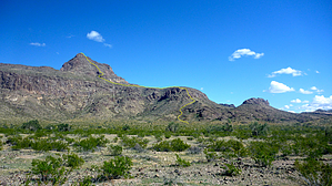
Hooked on the wilderness by chumley  Overview OverviewBig Horn Peak is the namesake peak in the Big Horn Mountains Wilderness 65 miles west of Phoenix. Gaining the summit requires a couple of hours of steep, off-trail climbing across dry, rocky, desert terrain. Warning This is an off-trail hike and should only be attempted by those comfortable with climbing desert peaks. This mountain range is very hot in summer and should only be attempted during cooler seasons. Typical desert obstacles exist ... thick cholla, loose scree, snakes, and some exposure. There is no shade and no water available anywhere on this route.
This route begins at the pedestrian-accessible bridge crossing the CAP canal (Granite Reef Aqueduct). Cross the bridge and follow the road to the right and then down off the raised canal bank. Proceed north along a fence line about 0.4 miles to the end of the fence. Turn east toward the mountain and loosely follow the fence line across the desert. Set your sights on the chimney at an old mining site and aim for it. This will be a landmark on your return as well. The chimney and mine site are about 1 mile from the pedestrian bridge crossing of the CAP canal. From the old mine site, proceed across the desert toward the southern ridge that climbs the peak. You want to stay to the right of the main drainage descending off the mountain. You will cross two large washes that drain the mountain before beginning the ascent (about 2.5 miles from the TH). Skip the smallest south peak and head up wherever you find the best route. There are some thick sections of brush, some steep sections to scramble, and some loose sections of footing. None of it is difficult for a hiker accustomed to desert terrain. Once at the top of the first climb, the route follows the ridge and occasional cairns lead the way. As you move north toward the peak, you will have to begin a more serious ascent. Staying too far right will leave you at the base of a cliff that you don't want to climb. Traversing too far left will put you in one of two drainages that are more difficult to negotiate. The best route is just to the left of the cliff band, but right of the main drainage the cliff ends at. There is a nice saguaro at the "corner" that is good to aim for. Once at the "corner" marked by the saguaro, the best route turns sharply to the right and climbs up, and puts you on top of the cliff after a steep, loose scramble. From here, the route turns back to the left and climbs straight up the fall line to a ridge on the right side below the peak. From here, traverse on the ridgeline over to the peak and make the final climb to the summit. The top is a class-3 scramble, but has minimal exposure due to the ridge/saddle that you come up from. The top of Big Horn Peak provides 360-degree views over this remote area west of Phoenix. Return by the same route back to your vehicle. Check out the Official Route and Triplogs. Leave No Trace and +Add a Triplog after your hike to support this local community. | ||||||||||||||||||||||||||||||||||||||||||||||||||||||||||||||||||||||||||||||||||||||||||||||||||||||||||||||||||||||||||||||||||||||||||||||||||||||||||||||||||||||||||||||||||||||||||||||