Route Editor

| Guide | ♦ | 9 Triplogs | 0 Topics |
details | drive | no permit | forecast | 🔥 route |
stats |
photos | triplogs | topics | location |
| 41 | 9 | 0 |
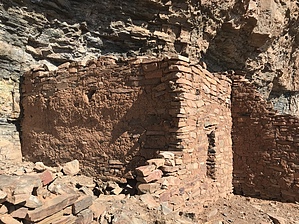
Bring an ICE AXE... (-: by Grasshopper  Overview OverviewThree routes to access the Sierra Ancha- Moody Point TR#140 Salado Cliff Dwelling/Ruins Site: 1) North - Moody Point TR/TH access via FR487-Workman's Creek Road 2) South - Moody Point TR/TH access via the Leisure TH on FR203-Cherry Creek Road 3) West - Deep Creek TR/TH access via the Bull Canyon TH at the barricaded end of FR203A Having now hiked all three of these routes, I am convinced that there is no easy way to reach this ancient(~700 years old) Salado Indian Ruins Site without a lot of effort (hiking miles with AEG, trail overgrowth, and needed route-finding skills). However, I believe that this 3rd west access route via the Deep Creek TR/TH offers the best all-around option. This route provides less driving miles than the Workman's Creek access, a much more scenic, remote driving route than the Leisure TH access, and with less needed route-finding skills than both the Workman's Creek and Leisure TH options.
Starting at the remote Bull Canyon TH (4825' N33 45.767 W110 52.912), this hike begins on a closed section of FR203A for 0.25mi where it intersects the east TH start of the Coon Springs TR#124. From here, you continue on closed FR203A, which is a nice, wide two-track gravel trail with large manzanita, alligator juniper, and some cedar lining your path on each side of this scenic, easy to follow cairned section of the Deep Creek Trail. You will continue mostly downhill (with many ups and downs) as you continue for a total of 2.4mi in on this closed section of old FR203A where you will cross Deep Creek(dry as of this writing) at 4925ft elevation. At this point in your hike, FR203A ends, and you will continue both uphill and downhill following a cairned trail for another scenic 1.5mi where you have some great views of the upper cliffs and ridge formations where on top the Moody Pt Trail is. You will soon come down to another nice drainage area where some beautiful old growth oaks reside. This spot is worthy of a snack stop or a few pictures! Continuing to follow the cairned trail with light catclaw and mostly thigh-high grass to sometimes block the trail. You now start a mostly uphill trail climb (some cairned trail to navigate in a creek drainage area) for a total of 5mi into the upper end of Deep Creek TR#128 at its intersection with the Moody Point TR#140(5450ft N33 47.629 W110 51.684). For some, this 5mi hike in would make for a nice ending point. If you want some additional challenges with rewards, please follow me: Turn south(right) on the Moody Point TR#140 and continue your ¿trail? journey as it enters a plateau area(contouring between 5500ft to 5200ft) for the next 0.9mi with a very faint, difficult trail to follow with high grass overgrowth(hiding the cairns) with some rocky areas under the grass at your feet to trip you. "Note": It is highly recommended that all first-time hikers attempting to negotiate this 0.9mi section of TR#140 (to SW saddle area at GPS waypoint N33 46.990 W 110 51.589) consider uploading this important waypoint and also uploading my HAZ-GPS Route dated 11/23/08 for the continuation of this hike to the RUINS and back. Once at this above-referenced waypoint (~5.9mi total in), you will begin a serious -400ft downhill with defined TR#140 to follow, but with significant overgrowth to 6.13mi down where you will now look up to your left (north), on the cliffs above where the obvious area resides for your ultimate destination this day (at N33 47.282 W110 51.496), the ~700-year-old Salado Indian Ruins Cliff Dwelling Site. There is no easy route up and back down, but hiking/climbing up (+250 steep feet) to this site is certainly doable but requires caution. Long pants and a long-sleeved shirt, gloves, hiking poles, and an ice ax (just kidding) would certainly help. Our group went up one way and came down this other way: I offer this GPS waypoint (N33 47.184 W110 51.396) as the preferred way up and back down if I were to try this again. This waypoint is on TR#140 at the first drainage area coming down from the cliff dwelling. You will see this drainage area as you approach this waypoint at ~6.13mi in. This drainage is tough, both going and coming with overgrowth and some trees and larger brush, but you will have some stable, larger rocks to climb up and down with somewhat less loose, rocky spree to deal with vs. some of the other immediate areas going up and down. This large Salado Ruins Site has mostly now crumbled with only one dwelling still intact (without the roof), but there are obvious footprints of more than 12 dwellings/buildings that did exist when now seems like eons ago. Also, every morning to the east, these ancient ones living on this cliff face had ONE KILLER OF A SUNRISE with near and distant MAJESTIC MOUNTAIN VIEWS to look forward too! Also, see Moody Point Trail #140 for numerous trip log pics of this ruins site. OK, it is time to boogie back the way you came in! I hate to remind you, but when you complete this total 12.8mi hike, you will have only completed +722ft elevation gain, but you will have clocked +3927ft AEG..how could that be? On the hike back, your body will confirm it. Another amAZing day! (-:
Check out the Official Route and Triplogs. Leave No Trace and +Add a Triplog after your hike to support this local community. | ||||||||||||||||||||||||||||||||||||||||||||||||||||||||||||||||||||||||||||||||||||||||||||||||||||||||||||||||||||||