username
X
password
register
for free!
help
 

Reay Lane Reclamation Ponds & Marsh, AZ

Guide 4 Triplogs  0 Topics
  2 of 5  
Fav
Wish
0
details
drive
no permit
forecast
map
stats
photos
triplogs
topics
location
21 4 0
Statistics
tap row or icons for details
Distance One Way 0 miles
Trailhead Elevation 2,863 feet
unreported if dogs are allowed
editedit > ops > dogs to adjust
feature photo
Photos Viewed All MineFollowing
7  2018-12-05 cactuscat
14  2013-09-23 SkyIslander18
Author
author avatar Guides 16,832
Routes 17,472
Photos 24
Trips 1 map ( 6 miles )
Age Male Gender
Location HAZ, TrailDEX
Historical Weather
Trailhead Forecast
Expand Map
Sun  6:28am - 5:39pm
0 Route
 
0 Alternative


remove free decal offer

Expand Map
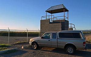
This wastewater reclamation facility in the Town of Thatcher just off Highway 70 provides excellent waterfowl and shorebird habitat and has yielded numerous rare bird sightings. Close to town and adjacent to the Gila River. There is an observation deck located at the southeast corner.


    Check out the Triplogs.
    Leave No Trace and +Add a Triplog after your birding observation to support this local community.
    WARNING! Hiking and outdoor related sports can be dangerous. Be responsible and prepare for the trip. Study the area you are entering and plan accordingly. Dress for the current and unexpected weather changes. Take plenty of water. Never go alone. Make an itinerary with your plan(s), route(s), destination(s) and expected return time. Give your itinerary to trusted family and/or friends.

     Permit $$
    None


     Directions
    or
     Road
    Paved - Car Okay

    To birding observation
    From US 191 & 70 in Safford, take 70 west for 3.80 miles through Thatcher. Turn right (north) on Reay Lane and take for 1 mile. Turn left and park at the observation deck.
    page created by SkyIslander18 on Sep 23 2013 7:23 pm
    helpcorrectionissue

    end of page marker