Route Editor

| Guide | ♦ | 7 Triplogs | 0 Topics |
details | drive | permit | forecast | route |
stats |
photos | triplogs | topics | location |
| 111 | 7 | 0 |
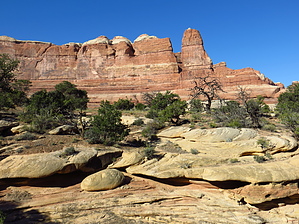
Up one canyon, down the next. by CannondaleKid  Hike: From the Squaw Flat Loop "A" Trail-head you begin by following a nice flat trail toward the right. About .25 mile from the TH you will reach the first slick-rock climb. After a short and easy climb you will enter Big Spring Canyon. The hiking is easy along the canyon bottom, which you will follow roughly 3 miles until reaching the southern end of Big Spring Canyon. Big Spring Canyon provides a reliable water source.
Once you reach the top of the slick-rock ridge you will be just shy of halfway around the loop so this is an excellent spot to take a break. Whether you take a break or not, please, by all means take a look in ALL directions from BOTH sides of the slick-rock ridge. You won't be sorry because the views are fantastic! If we weren't planning on another hike after this one I could easily have spent an hour or more to soak it in. From the ridge you will drop 300' relatively quickly down the slick-rock slope into Squaw Canyon. It may again appear intimidating, just use the rock cairns to guide you. Their was one pool of water that we could easily straddle. If there happened to be more water we would have had just a slightly steeper slope, yet nothing that we hadn't already handled. There will be one 4-5' drop from a pour-off but a few rocks were stacked there so it wasn't an issue. This is the one spot that it could present a bigger challenge if you were hiking clock-wise and solo. With two people it would be easy for one to boost the other, then give a hand to pull the other up. Just below this point you will see a sign at the trail junction where you will turn left to complete the loop. If you were to go to the right you would curve around to the west and be lead into Elephant Canyon, which would make for a LONG way around and back to the TH. So if you don't wish to double your mileage, turn left. From the junction you will continue .5 miles along a mostly-flat slick-rock ridge before dropping down a few ledges until you are parallel with and slightly above the creek. At the time of our hike (mid-October), although it didn't appear to be 'flowing' there was a reasonable amount of water. Eventually the trail reaches the creek level and you will cross back and forth a few times. If you get to a point where the water is too deep to cross, scan to your right (east side of the creek) for an alternate segment of trail a bit up and back from the creek. We first noticed it only where it reconnected with the trail maybe a hundred yards farther along. Leaving the creek you will have some flat easy hiking, a few short climbs up slick-rock, a short drop, cross another flat open area, one last short ascent and descent to a flat easy run back to the trail-head. Water Sources: Reliable in both Big Spring & Squaw Canyons. Camping: Yes, with back-country permits.
Check out the Official Route and Triplogs. Leave No Trace and +Add a Triplog after your hike to support this local community. | |||||||||||||||||||||||||||||||||||||||||||||||||||||||||||||||||||||||||||||||||||||