Route Editor

| Guide | ♦ | 5 Triplogs | 1 Topic |
details | drive | permit | forecast | route |
stats |
photos | triplogs | topic | location |
| 97 | 5 | 1 |
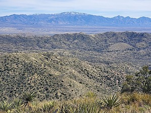
worst nightmare to unbeatable by HAZ_Hikebot   The view is unbeatable by Southern Arizona standards, you can see almost every recognizable mountain within 100 miles on a clear day. The only problem is getting to the peak. It's your worst off-trail nightmare filled with catclaw, Spanish dagger, prickly pear, cholla, sharp grasses, loose rock, and steep slopes. It's a worthy summit for peak baggers, but you really must be determined to get to the top. The view is unbeatable by Southern Arizona standards, you can see almost every recognizable mountain within 100 miles on a clear day. The only problem is getting to the peak. It's your worst off-trail nightmare filled with catclaw, Spanish dagger, prickly pear, cholla, sharp grasses, loose rock, and steep slopes. It's a worthy summit for peak baggers, but you really must be determined to get to the top.There may be a better route to the peak, perhaps from the North, we chose to start this trek near Oak Wells on the East side of the mountain. It's really up to you to find the path of least resistance as the vegetation is the biggest obstacle. The peak is visible from the trailhead area near the tower, so just start heading towards it.
Check out the Official Route and Triplogs. Note This is a moderately difficult hike. Leave No Trace and +Add a Triplog after your hike to support this local community. | |||||||||||||||||||||||||||||||||||||||||||||||||||||||||||||||||||||||||||