Ironwood Ridgeline 3108 Loop - Goldfield Mtns, AZ

Guide 37 Triplogs Mine 0 0 Topics
 
3.1 of 5 
Fav
Wish
0
details
drive
no permit
forecast
route  
stats
photos
triplogs
topics
location
355 37 0
Statistics
tap icons for details
Difficulty 4 of 5
Route Finding 3 of 5
Distance Loop 4.8 miles
Trailhead Elevation 1,923 feet
Elevation Gain 1,185 feet
Accumulated Gain 1,683 feet
Avg Time Round Trip 4 hours
Kokopelli Seeds 13.22
 Interest Off-Trail Hiking & Peak
unreported if dogs are allowed
editedit > ops > dogs to adjust
feature photo
Photos Viewed All MineFollowing
Will recalculate on button tap!
24  2022-03-26
Ironwood Ridgeline and Four Goldfield Peaks
John10s
19  2022-02-06 adamsonma
6  2021-02-13 azlaurie
12  2021-02-07
Four Goldfield Peaks
DixieFlyer
5  2019-12-20 hikerdw
13  2019-12-01 Yoder
10  2019-09-21
Hippy Hill 3163
chumley
10  2019-04-20 DarthStiller
Page 1,  2,  3,  4
Author
author avatar Guides 4
Routes 5
Photos 3,371
Trips 767 map ( 3,696 miles )
Age 53 Male Gender
Location Mesa, AZ
Associated Areas
list map done
Phoenix Region
Historical Weather
Trailhead Forecast
Radar Map
Expand Map
Preferred Feb, Jan, Dec, Nov
Seasons   Autumn
Sun  5:29am - 7:17pm
Official Route
 
6 Alternative
 
 Water
Nearby Area Water
[ View More! ]
Fauna  Nearby
Flora  Nearby
Geology  Nearby
Named place  Nearby
no photo labels yet
+Add > Photos to this Guide
then label as applicable
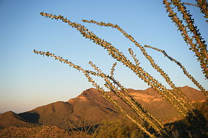
Brother of Pass
by RickVincent

Overview
A challenging off-trail ridge line adventure with good approach trails on both ends, completing the 4.8-mile loopWarning
The ridgeline portion of this hike is not oft traveled and covers rough rocky terrain. Travel with company or make sure someone knows where you will be hiking.

Hike
This is a true loop hike that starts and finishes at the Meridian TH. For this description, travel was counter-clockwise (ridgeline from south to north).

Start by taking the trail that heads north towards Bulldog Saddle. Within about 500 feet a trail splits off to the east. Follow this trail until its terminus at the south end of the mountain. The trail ending is obvious, and so are the heavily placed cairns which lead up towards the ridgeline.

Once on the ridgeline, the route requires boulder hopping, scrambling, and a few downclimbs. Exposure is minimal. The terrain very much resembles that of the nearby Pass Mountain ridgeline. After passing the highest point on the ridge, Peak 3108, there is just one more saddle and a slight climb to the final peak at the north end of the ridge.

From here, look down to the west at Boulder Saddle. Follow a cairned route down the north end to the saddle. Pick up the Boulder Saddle trail and follow back to the trailhead.

Camping
There is a nice camp spot in an open meadow at a saddle below the south end of the ridgeline. A large fire ring already exists and the area is secluded with great views.


Check out the Official Route and Triplogs.

Note
This is a moderately difficult hike.

Leave No Trace and +Add a Triplog after your hike to support this local community.

2013-12-27 RickVincent
    WARNING! Hiking and outdoor related sports can be dangerous. Be responsible and prepare for the trip. Study the area you are entering and plan accordingly. Dress for the current and unexpected weather changes. Take plenty of water. Never go alone. Make an itinerary with your plan(s), route(s), destination(s) and expected return time. Give your itinerary to trusted family and/or friends.

     Permit $$
    None


     Directions
    or
    or
     Road
    Paved - Car Okay

    To Meridian Trailhead
    Meridian Trailhead is located at the north terminus of Meridian Road between Mesa and Apache Junction.

    US60 to Signal Butte. Take Signal Butte north to University. East (right) onto University to Meridian. North (left) onto Meridian to the terminus. There is a small TH.

    or

    Exit 202 Loop at Brown Road and travel east on Brown Road for about 3.5 miles. From Brown Road (Lost Dutchman Rd), travel North on Meridian for two miles to the trailhead parking area at the end of the road.

    From PHX (I-10 & AZ-51) 34.1mi - 44 mins
    From TUC (Jct 1-10 & Grant) 119mi - 2hr 11mins
    From FLG (Jct I-17 & I-40) 176mi - 2hr 56mins
    page created by RickVincent on Dec 27 2013 10:05 pm
     90+° 8am - 6pm kills
    prehydrate & stay hydrated
    helpcorrectionissue

    end of page marker