Route Editor

| Guide | ♦ | 18 Triplogs | 0 Topics |
details | drive | permit | forecast | 🔥 route |
stats |
photos | triplogs | topics | location |
| 565 | 18 | 0 |
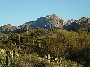
Awesome view of southern Superstitions! by CannondaleKid  Overview OverviewBegins with an easy-to-follow but rocky Jeep road, morphs to an ATV track, then a reasonably well-defined trail, to a hard-to-follow trail, to heavy bushwhack, steep climbing up and traversing across slopes and ends with a long steady slope climb to one of the most awesome views of the southern Superstition Wilderness from just outside of it. (Using the official GPS route you will follow along the Tonto NF/Superstition Wilderness boundary for a short distance.) Warning Plenty of catclaw so if you aren't prepared (duh... long pants) don't blame me if it draws blood along the way.
Fraser Benchmark was placed at the summit of Peak 4618 in 1938. Hike From the 'official' TH while the scenery hiking up the canyon is impressive, you may soon get bored of the terrain you will be on for the first 1.5 miles or so... mostly rough rock-hopping along the old Jeep road, which continues along the ATV track. But don't worry, the boredom of that will soon be supplanted by avoiding as much of the thorny vegetation as possible while picking your way up to and past Eagle Spring. Hint To minimize the amount of thick and thorny bushwhacking, I'd recommend you follow the official GPS track, especially as you approach Eagle Spring unless of course, you WANT to visit the spring in the midst of a very thick creek bed. (Tracey and I learned this by experience in 2012) While you may wish to skirt the drainage along the east (right) side, or go hard-core and bust along up the center of the drainage... unless you want to prolong the agony, I have one word for you, don't! My recommendation is to stay to the left, staying up and out of the drainage up to the saddle at the ridge. Whenever the brush gets thicker, just climb a bit higher to your left and you will be glad you did. Whatever you do, don't attempt to follow the center of the drainage as there are numerous dry falls amidst the heavy brush. If you keep a close watch you may make out some lightly traveled game trails or even remnants of heavier used trails (by human as well as game) they will help you avoid the worst of the terrain, although they can just as easily fade away. Once you reach the ridge, don't attempt what looks to be an 'easy' route along the southern base of the ridge, but rather pass over the saddle and traverse the 'back' side of the ridge east toward the summit. While you could stay slightly south below the ridge all the way up, if you follow the official GPS track you will turn up to the ridge where you see what looked to me like some kind of obelisk with a small vertical opening (I almost expected a lit candle in it). This may seem like an extra effort, it's worth it because it will bring you to the top of the ridge. From that point, you simply follow the top of the ridge to the east. Another hint as you approach the summit... don't aim straight for the summit. While it may be a slight bit shorter and appear to be easier, it isn't! (I took it on the way down and I was quite sorry I tried it!) Follow the GPS track and ascend the rise to the left of the summit (no, it is NOT the 'peak' off to the south like you may have thought at the start of the hike) until you see a small saddle across to the summit. This route is steep and rocky, but take my word for it, it's easier and you're less likely to turn an ankle on loose rocks hidden in the grass of the slope more direct to the summit. At the summit, the benchmark is right out in the open just to the right of the summit log cairn. You may have even walked over Reference Mark #1 3.645 meters before you reach the actual Fraser Benchmark. And 4.109 meters to your left (north) next to a bush you will find Reference Mark #2. NOTE: The benchmark isn't quite the highest point, so continue on eastward another 25-30 feet and you will reach the summit of Peak 4618. But even at that point my GPS only showed 4602'. Taking a glance at the benchmark datasheet you will note a variance in the elevation over the years, with it being pegged at 4619' in 1965 when last checked, by a crew dropped from a helicopter... but that's cheating! ;-) SUMMIT Be sure to stop, drop your pack, and stay awhile! And take in the awesome views of the southern Supes! I'm definitely going to return... maybe using the alternate route?? Alternate Route While there very well may be a reasonable route to the summit to the northeast from Eagle Spring, I did not try it this trip. By turning 45 degrees to the right at Eagle Spring and continuing northeast up to a point below what appears to be the high point then arcing around it to the northwest, and finally turning back northeast and up to the summit. Water Sources Eagle Spring had some water in December 2012 but I can't say in Jan 2014 as I avoided it completely. However, I did note a few very small pools of water above the spring. Camping Might be nice up near the summit, but I seriously doubt many folks would even think of camping. Check out the Official Route and Triplogs. Leave No Trace and +Add a Triplog after your hike to support this local community. | ||||||||||||||||||||||||||||||||||||||||||||||||||||||||||||||||||||||||||||||||||||||||||||||||||||||