Route Editor

| Guide | ♦ | 2 Triplogs | 0 Topics |
details | drive | permit | forecast | route |
stats |
photos | triplogs | topics | location |
| 32 | 2 | 0 |
Scenic Exercise by JimmyLyding  The area around Stinson Beach was once known as Willow Camp which was a tourist camp reachable by train from Mill Valley then stagecoach from the West Point Inn up on Mount Tamalpais. Automobiles eventually reached Stinson Beach, renamed in 1916, and it's now one of the many quirky little hamlets on Hwy. 1.
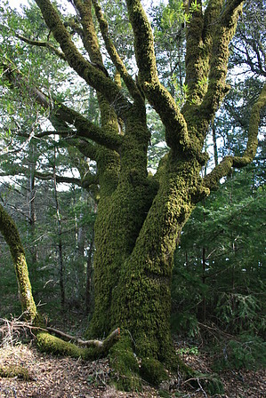
The first portion is long switchbacks, 4 in all, through a relatively open (and steep) hillside. There is very little shade here so a summer hike would be pretty warm. Wind is rare on this stretch as it's too high for sea breezes and too low for the typically-strong gusts up top. The flora here is typical coastal scrub with a few scraggly Douglas firs mixed in. The trees get bigger and the forest closes in about a mile up from the junction. Large misshapen Douglas firs are joined by towering live oaks as the sun disappears. Redwoods don't grow this close to the coast, but this little patch of woods must receive a lot of water from fog and mist. Most of the trees are draped in moss that looks like fur, but it was dry today (January 25, 2014). The upper reaches of this ridge have dense forests amongst larger areas of open (and steep) grassland. There's a short downhill portion when the top is in sight before a final steep stretch right before the trail reaches Ridgecrest Boulevard. There is parking here for about a dozen cars on both sides of the road, and this is a common starting point for hikes on the north side of Mount Tamalpais. There is a small peak about 150 yards north on Ridgecrest that has a great view north of Alpine Lake, Pine Mountain and Barnabe Mountain. Return the way you came. The views are much better on the way down, and this would be a great sunset hike. It's so steep that going downhill is still a nice workout. Gate Policy: If a gate is closed upon arrival, leave it closed after you go through. If it is open, leave it open. Leaving a closed gate open may put cattle in danger. Closing an open gate may cut them off from water. Please be respectful, leave gates as found. The exception is signage on the gate directing you otherwise. Check out the Official Route and Triplogs. Note This is a moderately difficult hike. Leave No Trace and +Add a Triplog after your hike to support this local community. | ||||||||||||||||||||||||||||||||||||||||||||||||||||||||||||||||||||||||||||||||||||||||||||||||