 Route Editor

| Guide | ♦ | 3 Triplogs | 0 Topics |
details | drive | no permit | forecast | map |
stats |
photos | triplogs | topics | location |
| 11 | 3 | 0 |
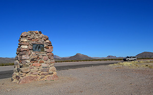
ambushed by HAZ_Hikebot   Roadside marker inscription - In Memory of two of the many pioneers who brought law, order, and safety to the Gila Valley. Lorenzo and Seth Wright were killed 1 mile north of this spot by Indians who had stolen 45 horses from early settlers. While pursuing the Indians they were ambushed Dec. 1, 1885 (marker placed in 1938). Roadside marker inscription - In Memory of two of the many pioneers who brought law, order, and safety to the Gila Valley. Lorenzo and Seth Wright were killed 1 mile north of this spot by Indians who had stolen 45 horses from early settlers. While pursuing the Indians they were ambushed Dec. 1, 1885 (marker placed in 1938).An old high clearance dirt road north of the marker takes you 0.75 miles across the desert floor to the ambush marker. Check out the Triplogs. Leave No Trace and +Add a Triplog after your hike to support this local community. One-Way Notice This hike is listed as One-Way. When hiking several trails on a single "hike", log it with a generic name that describes the hike. Then link the trails traveled, check out the example. | |||||||||||||||||||||||||||||||||||||||||||||||||||||||||||||||||||||||


