Route Editor

| Guide | ♦ | 24 Triplogs | 0 Topics |
details | drive | no permit | forecast | route |
stats |
photos | triplogs | topics | location |
| 135 | 24 | 0 |
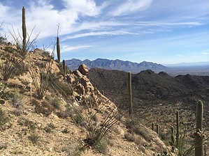
Hit all the Tortolita trails at once! by azdesertfather   Want to experience the Tortolitas and soak up as much of them as you can in one day? Take in pretty much all the views that its trails have to offer? Then this is the hike for you! Want to experience the Tortolitas and soak up as much of them as you can in one day? Take in pretty much all the views that its trails have to offer? Then this is the hike for you!This super loop covers the entirety of a few of the trails in the mountain range and touches briefly on all of the others. On this super loop, you see views throughout your western, southern, and eastern line of sight, from Picacho Peak in the northwest to Mount Lemmon to the east. It also takes advantage of some of the newly constructed trails in the Tortolita system. Due to shade and ease of navigation, I recommend this hike in a clockwise fashion.
Follow Wild Mustang almost a half-mile until you hit Cochie Springs Trail and hike pretty much the entirety of this trail. Officially, this trail at the northern end picks up a dirt road and goes to the Pinal County line, though the road continues into Pinal County, to Cochie Spring and beyond. At about the 5-mile mark, you will hit this road and only hike it as part of the Cochie Spring trail for about 0.4 mi before you turn off of it and onto a very faint and almost unnoticeable, unofficial trail. This is the trickiest route-finding part of the trip, though it isn't that bad. Once the trail dumps you onto the dirt road, start watching your GPS. In this area near the end of Cochie Canyon Trail there is a windmill. I passed this unofficial trail at first, not seeing it, then backtracked and wandered around a bit with the GPS until I picked up on its faint trail. At this portion of the super loop, you will be on the old, unofficial trail. Further along you’ll see a beautiful crested saguaro. You’ll be on this trail for 2.1 mi, climbing a short, steep ridgeline and then heading down a drainage until you reach the spot where Wild Mustang crosses that drainage, at about the 7.6 mi mark. Turn left onto Wild Mustang and hike a quarter mile until it dead-ends into Wild Burro Trail. Take a left onto Wild Burro toward Wild Burro tank (unless you want to abandon your trip and head straight down). It’s 2 1/4 mi to the tank and an old homestead area. Along the way you will see a grave marker for a 23-year-old girl named Molly. Once you make it to the tank, you have hit a good lunch spot. Up here, if you look carefully, you’ll find a windmill, tank & water trough, a small dam, the remains of a couple of stone buildings and a stone corral. (If you’re interested in doing a traverse from here and out the eastern edge of the Tortolitas, from this homestead, you can follow the 4WD road up the ridge and over…it will wind down the mountainside and eventually make its way onto Edwin Road or “Rail X” Road, which goes east to Hwy. 77 in Catalina.) Once you arrive at the Wild Burro Tank (you'll see it off to your right), the trail will continue up and to your left. You will soon hit the Loop Trail signage, which carries you 1.7 mi to the Ridgeline. You’ll be on the Ridgeline Trail about 3.2 miles and see some beautiful views of the south and east and down Ruelas Canyon. Many would say this is the best part of the loop, with views to Baboquivari & Kitt Peak to the southwest and Four Peaks to the north. When you complete this trail, it dumps you into the Alamo Springs Trail. Take a left, heading down Alamo Springs about 3/4 mi to the Alamo Springs Spur Trail. Follow the spur further down the canyon 1/2 mi until it dumps you into Wild Burro again. Follow Wild Burro down the big wash about a 1/2 mile until you see the signs for Lower Javelina Trail on your left. At this point, take one of the lower Javelina routes: you can either turn right and do about 0.8 mi of Lower Javelina on the western side of Wild Burro Canyon or take a left and follow it for 0.9 mi on the eastern side. I recommend and did the route down the east side. I know… it’s been a long day, and you’re tired! WHY start doing elevation again, climbing up one of Lower Javelina routes when you can take the easy route and follow the Wild Burro drainage easily back to your car? Because this is a super loop! That’s why. Jumping onto Lower Javelina will complete your count of hiking some or all of every official trail in the Tortolitas, so you don’t want to pass that up. And you’ll get some final lovely views as you approach the resort and of the slackers tromping through Wild Burro Wash below you. If you follow the Lower Javelina Trail on the eastern side, it dumps back into the Alamo Springs Trail. Take a right on Alamo Springs Trail to head down into Wild Burro once again for the remaining piece out via the wash. Check out the Official Route and Triplogs. Leave No Trace and +Add a Triplog after your hike to support this local community. | ||||||||||||||||||||||||||||||||||||||||||||||||||||||||||||||||||||||||||||||||||