Route Editor

| Guide | ♦ | 17 Triplogs | 0 Topics |
details | drive | permit | forecast | route |
stats |
photos | triplogs | topics | location |
| 175 | 17 | 0 |
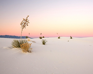
If you want to see unvegetated dunes stretching for miles into a beautiful vista and have a wilderness-type experience, the Alkali Flat Trail is for you. This trail takes you through the Heart of the Sands, up and over dunes, and ends at the edge of the Alkali Flat. This trail is approved for foot travel only. No bicycles, horses, or motorized vehicles are allowed. Warning The air space above the park is periodically used by military aircraft and for missile testing. Debris from testing occasionally falls into the park. DO NOT TOUCH ANY METALLIC OBJECTS. These can be dangerous. Report any debris to a park ranger. There is no shade or water along the trail, and summer temperatures can exceed 100 degrees F (38 ° C). Heat-related illness is common in warm weather and can be fatal. Hike during cool times. Carry food and at least two quarts of water. Rest, eat and drink when tired. Drinking water is available only at the Visitor Center. The white sand reflects sunlight. Protect all exposed skin from sunburn. Protect your eyes by wearing sunglasses.
The Alkali Flat is the dry lakebed of Lake Otero, a lake that filled the bottom of the Tularosa Basin during the last ice age and covered 1,600 square miles. Please note that you do not have to hike the entire trail to enjoy the spectacular scenery. Hike The trail is marked by white posts with orange reflective tape at the top, so look carefully for the next trail marker before continuing. If you cannot see the next post because of blowing sand or dust -- do not proceed. Turn back. The strong winds, especially in the spring, can reduce visibility to a few feet, making it easy to get lost. Please be sure to sign in and out at the register at the trailhead, so we know you got back safely. White Sands is a unique place in many ways - hiking across the white gypsum sand dunes is a one of a kind experience. Typical sand dunes are usually composed of quartz, but these dunes are entirely made up of gypsum, which yields a very uniform grained sand that is soft to touch and a brilliant white. The minerals dissolve out of the surrounding mountains and concentrate into Lake Lucero. Here the gypsum precipitates out into selenite crystals that eventually get broken down into fine white sand. Westerly winds drive these sands in an eastern direction making graceful dunes - you find several different types of dunes here - Barchan, Parabolic dunes, Reverse Parabolic Dunes, Dome Dunes, and Transverse Barchans. The Alkali Flats trail takes you through the Heart of the Dunes out to the flat lake bed, primarily through Transverse Barchan-type dunes. This hike starts at the end of the Dunes drive. Register at the trailhead and make sure you can return to the trailhead with 1 hr of sunset (when the park closes). Rangers check the TH and book to ensure everyone gets out. The trail heads west all the way out to the Alkali Flats (lake bed) and returns. San Andres Mountains stay in your line of sight the entire way out. The trail is marked by white /orange posts that allow you to navigate from point to point as you traverse the deep dunes - some towering above you for 60-70ft. Do not proceed if you cannot see the next post because of blowing sand or dust. Strong winds, especially in the spring, can reduce visibility to a few feet, making it easy to get lost. Ensure you get your bearings when you head out with the landmarks on the horizon around this area. As you pick your way up dunes faces and travel inter-dune areas, you will see relics of past dunes and their every onward march. The inter-dune areas are covered with ridges of old dunes - these ridges are left behind where the water /salts bind the gypsum into a harder composite right at the base of old dunes. You will see succeeding ridges and also see that today's dunes are moving in slightly different directions. The inter-dune area allows for a smattering of grasses, but overall you will see no major vegetation for the entire hike - Just layer after layer of majestic dunes. There is one great example of a skunk bush sumac whose dune had moved on, leaving it perched high up on its cylindrical pedestal, which its roots had captured. At 2.1 miles, the trail leads into the Alkali Flat - Follow markers back into the dunes to return - You will be heading back east with the mountains in view now and the lights of Alamogordo ahead of you. San Andres Mountain is to your back now. Follow the markers back to the trailhead. You retrace your steps or make a loop or cross country if you can navigate well - just don't get lost! There is no shade or water along the trail, and summer temperatures can exceed 100 degrees F (38 C). Hike during cool times. The white sand reflects sunlight. Protect all exposed skin from sunburn. Protect your eyes by wearing sunglasses. Water Sources The only water source is at the White Sands National Monument visitor center, 7 miles (11.2 km) from the trailhead 32.779634, -106.172450. Camping Camping is not allowed in this hiking area, but there are 10 Backcountry Primitive Camping sites available with a permit on a first-come, first-served basis in WSNM. Which are reached from a trailhead on the Dunes Drive, about 6 miles from the Visitor Center. It is about a one-mile hike into the campsites. The campsites are primitive, with no water or toilet facilities. No ground fires are permitted at the campsites or anywhere else in the park; however, containerized fuel is permitted. Anyone wishing to use a backcountry campsite must obtain a permit at the Visitor Center between 8 a.m. and one hour before sunset. Backcountry permits are limited and available only in person on the day of use, on a first-come, first-served basis. Pets are allowed on this trail but must remain on a leash at all times. Make sure you clean up after them. Please avoid walking on vegetation. Please do not remove any sand, plants, animals, or other natural and historical objects. They are protected by law. Guide posted by @desertgirl 2008-12-17. Co-Author @aWill & @joebartels revised 2014-09-14. Check out the Official Route and Triplogs. Leave No Trace and +Add a Triplog after your hike to support this local community. | ||||||||||||||||||||||||||||||||||||||||||||||||||||||||||||||||||||||||||||||||||||||||||||||||||||||||||||||||||||||||||||||||||||||||||||||||||||||||||||||||||||||||||||||||||||||