username
X
password
register
for free!
help
  🔥

Trans Goldfield, AZ

Guide 6 Triplogs  0 Topics
  5 of 5  
Fav
Wish
2
details
drive
no permit
forecast
🔥
route  
stats
photos
triplogs
topics
location
110 6 0
Statistics
tap row or icons for details
Difficulty 3 of 5
Route Finding 3 of 5
Distance One Way 14.2 miles
Trailhead Elevation 1,438 feet
Elevation Gain 1,175 feet
Accumulated Gain 2,525 feet
Kokopelli Seeds 22.61
 Interest Off-Trail Hiking
feature photo
Photos Viewed All MineFollowing
Will recalculate on button tap!
11  2025-07-27 DarthStiller
6  2024-06-15
Rough Eye Javelina Loop
ddgrunning
15  2024-01-20
Trans Goldfield Alternate
clayncallaway
7  2021-11-28
Transgoldfield extravaganza
brainz94
9  2021-11-28 brainz94
37  2019-02-06 Sonoranbob
25  2017-03-04 hikingaz2
Author
author avatar Guides 16,843
Routes 17,472
Photos 24
Trips 1 map ( 6 miles )
Age 28 Male Gender
Location HAZ, TrailDEX
Associated Areas
list map done
Phoenix Region
Historical Weather
Trailhead Forecast
Radar Map
Expand Map
Preferred Feb, Jan, Dec, Nov
Sun  6:03am - 6:47pm
Official Route & 2 Rts
 
2 Alternative
 
Historic Fire Perimeteracres
🔥 2024 Siphon Fire35.9 mi*


Notice
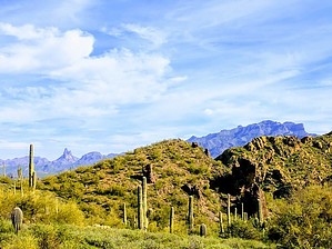
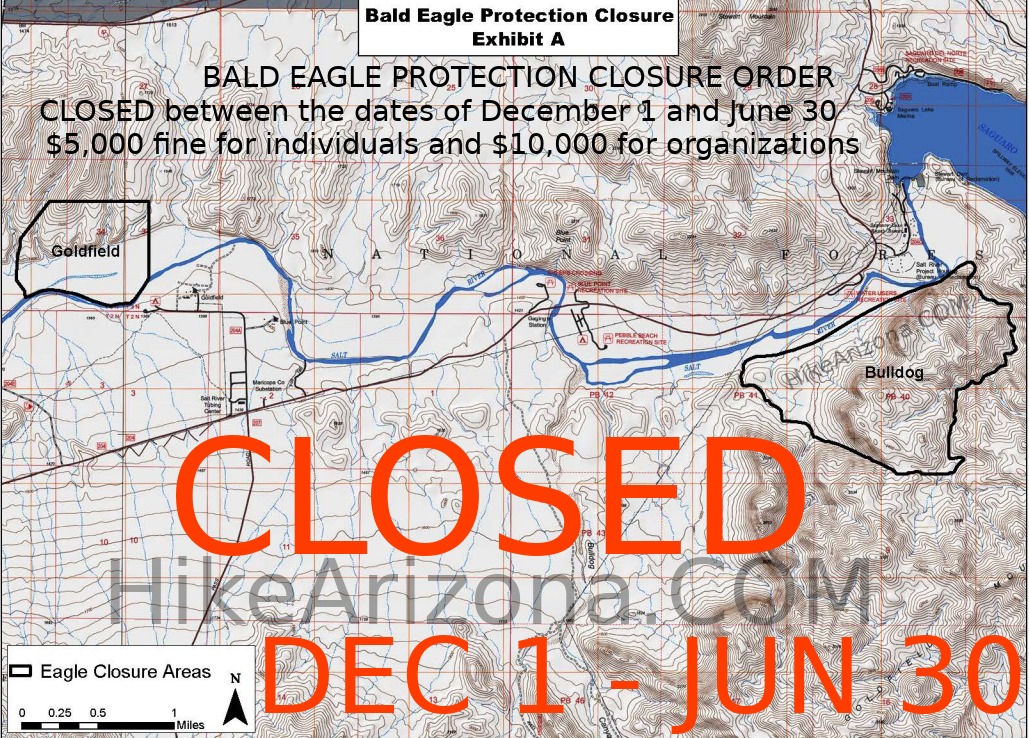
An area of this hike is closed Dec 1st - Jun 30th.

This hike traverses the Goldfield Mountain Range from West to East, from the Bush Highway to the Apache Trail.


Warning
Do not underestimate this hike. This is a physically difficult route when done in only 1 day. There is no cell phone coverage in this area. The odds are great that you will not see another person the entire time. Hikers should familiarize themselves with the trip logs suggested, be equipped with maps, GPS, and survival gear before attempting. It can be set up as a shuttle or key exchange.
remove free decal offer
There is some trail at the beginning and end of this hike but the middle 10 miles can be a brutal bushwhack involving scrambling and bouldering. The individual hikes complete with GPS routes are simply that, a route not a trail. The canyons and washes are subject to change due to floods, growth, and rocks moving. Pick the best way through.

The route as given can be done in either direction with variations.

2018-07-14 HAZ_Hikebot
  • Closure Map
    area related
    Closure Map


Check out the Official Route and Triplogs.
Leave No Trace and +Add a Triplog after your hike to support this local community.

One-Way Notice
This hike is listed as One-Way.

When hiking several trails on a single "hike", log it with a generic name that describes the hike. Then link the trails traveled, check out the example.
WARNING! Hiking and outdoor related sports can be dangerous. Be responsible and prepare for the trip. Study the area you are entering and plan accordingly. Dress for the current and unexpected weather changes. Take plenty of water. Never go alone. Make an itinerary with your plan(s), route(s), destination(s) and expected return time. Give your itinerary to trusted family and/or friends.

 Permit $$
None


 Directions
or
 Road
Paved - Car Okay

To hike
Take Bush highway east from Thomas or Usery to the trailhead just west of Blue Point Bridge or take Bush highway from Saguaro lake West to just across the Bridge. Multi-car parking in a small lot just off the highway.
page created by AZLOT69 on Feb 09 2014 6:52 pm
 90+° 8am - 6pm kills
helpcorrectionissue

end of page marker