Route Editor

| Guide | ♦ | 8 Triplogs | 0 Topics |
details | drive | no permit | forecast | 🔥 route |
stats |
photos | triplogs | topics | location |
| 177 | 8 | 0 |
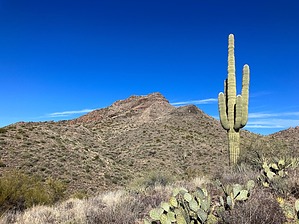
Davenport: Not just a Quad City by John10s  Overview OverviewDavenport Peak (4,010') is a seldom-visited summit in the western Mazatzals, located between Davenport Wash Trail #89 to the north and Sears Trail #90 to the south. The route described here is an out-and-back track that starts from Horseshoe Dam, follows forest roads to Sears Trail, then eventually leaves Sears Trail to ascend the southeast side of the peak. Triplogs contain descriptions of alternate routes, including loop options and approaches from Davenport Wash Trail. Hike If you can get a vehicle across the Verde River and drive to Sears Trailhead, you can skip hiking the forest roads and shorten the hike by ~3.3 miles each way. Otherwise, park in the wide dirt pullout along Horseshoe Dam Road just southwest of Horseshoe Dam, then cross the walkway to the east side of the dam, where you'll get your first unobstructed views of Horseshoe Reservoir. From there, start the flat, easy hike along FR 479 toward K.A. Ranch. Approaching the ranch, some nice saguaro forests appear on the north side of the road, and the cliffs south of the ranch are covered with interesting spires.
From the trailhead sign, the route continues along FR 477 past Sears Trailhead Spring, then eventually leaves the road just after a Copper Camp Trail sign and starts following a circuitous cairned path along Davenport Wash, winding through brush and around or through various drainages. The cairns through this stretch are large, but due to the brush and the meandering route, they can be tough to spot, so the GPS track comes in handy through this area. The route eventually crosses another drainage and emerges near some tall cliffs. Continue following the cairns past an impressively tall saguaro. The trail becomes easier to spot as it turns to the northeast and ascends between the cliffs, then continues gradually gaining elevation through the Mazatzal Wilderness boundary ~6.1 miles into the hike. The trail remains obvious for the next stretch, passing a corral ~1.5 miles beyond the wilderness boundary, and Davenport Peak, which is visible for much of the hike, becomes increasingly prominent ahead of you. Sears Trail starts to become more overgrown again as it circles the southwest side of the peak and passes a series of unnamed springs, where you may encounter a little water and green foliage in the creek bed. Past the springs and some low cliffs, leave the trail south of Davenport Peak. Once you're out of the creek bed, you'll get your first views of the peak from this southern vantage point. The posted route continues northeast, climbing a ridge toward the southeast side of the peak. In general, the brush isn't too dense, so dodging the sharper stuff doesn't present too much of an issue. There's a lower ridge south of the peak; as you approach the base of the mountain, aim for the saddle between the peak and that ridge. Though the approach is steep, there's a lot of solid rock among the grass that provides solid footing. The route steepens further near the top, and there's some light class three scrambling required to get up the rock outcroppings and reach the top. There are more loose rocks near the top, so double-check hand and footholds on the way up. Once on top, follow the narrow ridge north to the summit cairn, where you'll find a summit register. Based on the number of entries, Davenport Peak doesn't get many visitors, averaging around one per year over the past decade. The summit offers beautiful 360° views, with many of the popular Mazatzal summits visible to the west, including Sheep Mountain, Mt. Peeley, Mt. Catherine, Saddle Mountain, and Mazatzal Peak. To the east, you can see Horseshoe Reservoir and many of the peaks in the line of mountains overlooking Horseshoe, including Humboldt Mountain, Maverick Butte, and Kentuck Mountain, along with more distant ranges. Leaving the summit, you can return via the same route or consider one of the loop options described in triplogs. Check out the Official Route and Triplogs. Leave No Trace and +Add a Triplog after your hike to support this local community. | ||||||||||||||||||||||||||||||||||||||||||||||||||||||||||||||||||||||||||||||||||||||||||||||||||||||||||||||||||||||||||||||||||||||||||||||||||||||||||||||||||||||||||||||||||||||||||||||||||||