username
X
password
register
for free!
help
 
   🔥

Huerfano Butte, AZ

Guide 0 Triplogs  1 Topic
  0 of 5  
Fav
Wish
1
details
drive
permit
forecast
🔥
route  
stats
photos
triplogs
topic
location
20 0 1
Statistics
tap row or icons for details
Difficulty 1 of 5
Distance One Way 0.25 miles
Trailhead Elevation 3,744 feet
Elevation Gain 300 feet
Kokopelli Seeds 1.25
 Interest Off-Trail Hiking, Historic & Peak
feature photo
Photos Viewed All MineFollowing
2  2014-02-17 philbeer
Author
author avatar Guides 16,843
Routes 17,472
Photos 24
Trips 1 map ( 6 miles )
Age 28 Male Gender
Location HAZ, TrailDEX
Associated Areas
list map done
Tucson Region
Historical Weather
Trailhead Forecast
Radar Map
Expand Map
Preferred Mar, Nov, Apr, Feb
Sun  6:00am - 6:44pm
Official Route
 
0 Alternative
 
Historic Fire Perimeteracres
🔥 2017 Sawmill Fire14.2k


remove free decal offer

 
Guide Needed
Publish Full Detail Guide


Use +Add above to share photos and triplogs
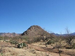
Primary route (north side of Huerfano Butte) is bushwhacking/rock hopping route. A short morning jaunt up the Huerfano (orphan) Butte, taking 15-45 min depending on your fitness and stops for views and pictures.


    Check out the Official Route.
    Leave No Trace and +Add a Triplog after your hike to support this local community.

    One-Way Notice
    This hike is listed as One-Way.

    When hiking several trails on a single "hike", log it with a generic name that describes the hike. Then link the trails traveled, check out the example.
    WARNING! Hiking and outdoor related sports can be dangerous. Be responsible and prepare for the trip. Study the area you are entering and plan accordingly. Dress for the current and unexpected weather changes. Take plenty of water. Never go alone. Make an itinerary with your plan(s), route(s), destination(s) and expected return time. Give your itinerary to trusted family and/or friends.

     Permit $$
    AZ State Recreational Land Permits
    For hiking, driving & sightseeing purposes, you seek a recreational permit.
    Under "Recreational Land Use" in the link above.
    2022 - $15.00 individual
    2022 - $20.00 family limited to two adults and children under the age of 18
    Plus $1 processing fee
    The permitting process is quick, you will be emailed your permit instantly.

    Land Parcel Map


     Directions
    or
     Road
    FR / Dirt Road / Gravel - Car Okay

    To hike
    From I19 & Sahuarita Exit,
    1. Head east E Sahuarita Rd for 2.5mi.
    2. Turn right onto S Santa Rita Rd continue for 10.1 mi
    page created by philbeer on Feb 17 2014 6:59 pm
     90+° 8am - 6pm kills
    helpcorrectionissue

    end of page marker