Route Editor

| Guide | ♦ | 15 Triplogs | 2 Topics |
details | drive | permit | forecast | 🔥 route |
stats |
photos | triplogs | topics | location |
| 211 | 15 | 2 |
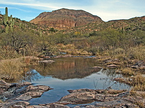
Canyons are inherently risky. Flash floods occur without notice on sunny days. Technical skills & surrounding topography knowledge required yet does not eliminate risk.
The other Needle Canyon by kanode  This is a creekbed hike through Needle Canyon in the Red Hills. The hike starts at the First Water trailhead, heads south on the Dutchman trail, then east on the Boulder Canyon Trail to the entrance to Needle Canyon. The exit from Needle Canyon runs into the Bull Pass Trail which is used to return to the Dutchman trail and back to the First Water trailhead. This Needle Canyon has nothing to do with Weaver's Needle but is named for a white needle on the east side of the Boulder Canyon trail roughly halfway between the Bull Pass and Cavalry trails. It's the only obvious route headed east in the area. This is a creekbed hike through Needle Canyon in the Red Hills. The hike starts at the First Water trailhead, heads south on the Dutchman trail, then east on the Boulder Canyon Trail to the entrance to Needle Canyon. The exit from Needle Canyon runs into the Bull Pass Trail which is used to return to the Dutchman trail and back to the First Water trailhead. This Needle Canyon has nothing to do with Weaver's Needle but is named for a white needle on the east side of the Boulder Canyon trail roughly halfway between the Bull Pass and Cavalry trails. It's the only obvious route headed east in the area.The only route-finding challenge was picking up the point where the creek crosses the Bull Pass Trail. The creekbed is wide at that point and has two channels. On the first attempt, we went past the intersection. On backtracking, we found the trail and cairns hidden in tall grass but the trail was within 100 feet of where the GPS said it should be. If you are nearing a large tree (a cottonwood from the leaf color), you've gone too far.
The Boulder Canyon segment hasn't seen much recent traffic and is somewhat overgrown. Hikers may be using the creekbed when it's dry rather than using the path on the benches. According to Tom Kollenborn's Chronicles, a miner named Al Morrow lived and worked in this canyon for 19 years. No details are provided on the location of the mine and we didn't see any trace of it or any artifacts. The start of Needle Canyon is not where it's shown on Topo maps. The early section starts about 500 feet north of the map location (north of the 2300' butte rather than south of it) and makes several big U-turns not shown on the map. From the point the canyon makes a major move south, the map is accurate. The side trails which loop in front of Red Hills Mtn 2073 and then head north to connect to the Cavalry trail were brushy and didn't seem worth the effort. Check out the Official Route and Triplogs. Leave No Trace and +Add a Triplog after your canyon trip to support this local community. | ||||||||||||||||||||||||||||||||||||||||||||||||||||||||||||||||||||||||||||||||||||||||||||||||||||||||||||||||||||||||||||||||||||||||||||||||||||||||||||||||||||||||||||||||||||||||||||||||||||||||||||||||||||